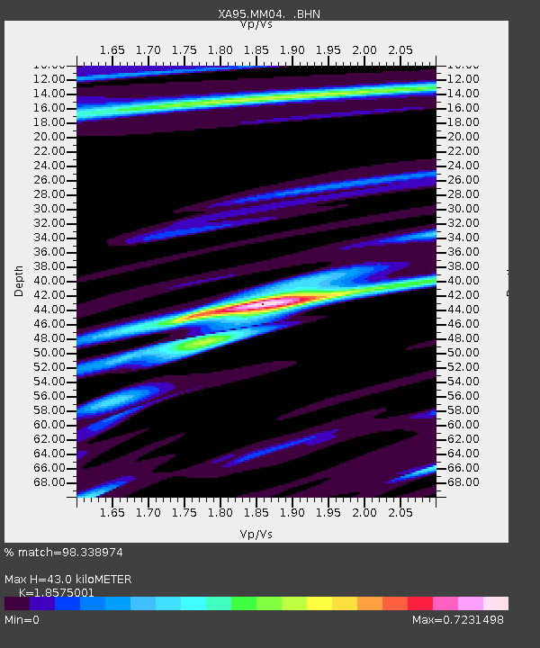
MM04 LeRaysville, Pennsylvania - Earthquake Result Viewer
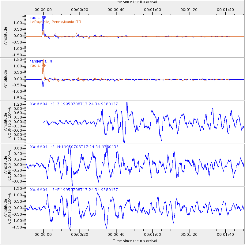
Earthquake location: Unimak Island Region, Alaska
Earthquake latitude/longitude: 53.6/-163.5
Earthquake time(UTC): 1995/07/08 (189) 17:15:28 GMT
Earthquake Depth: 33 km
Earthquake Magnitude: 5.8 MB, 5.7 MS, 5.5 UNKNOWN, 6.0 MW
Earthquake Catalog/Contributor: WHDF/NEIC
Network: XA Missouri to Massachusetts Transect
Station: MM04 LeRaysville, Pennsylvania
Lat/Lon: 41.85 N/76.20 W
Elevation: 473 m
Distance: 56.3 deg
Az: 63.753 deg
Baz: 314.378 deg
Ray Param: 0.06416506
Estimated Moho Depth: 43.0 km
Estimated Crust Vp/Vs: 1.86
Assumed Crust Vp: 6.121 km/s
Estimated Crust Vs: 3.295 km/s
Estimated Crust Poisson's Ratio: 0.30
Radial Match: 98.338974 %
Radial Bump: 126
Transverse Match: 91.84465 %
Transverse Bump: 385
SOD ConfigId: 6273
Insert Time: 2010-02-26 17:45:02.339 +0000
GWidth: 2.5
Max Bumps: 400
Tol: 0.001

Signal To Noise

ChannelStoNSTALTA
XA:MM04: :BHN:19950708T17:24:34.938013Z3.55336522.2037038E-76.201738E-8
XA:MM04: :BHE:19950708T17:24:34.938013Z6.4046765.5281873E-78.631486E-8
XA:MM04: :BHZ:19950708T17:24:34.938013Z5.6043724.867475E-78.68514E-8
Arrivals
Ps6.3 SECOND
PpPs19 SECOND
PsPs/PpSs26 SECOND