You are here: Home > Network List > G - GEOSCOPE Stations List
> Station ATD Arta Cave - Arta, Republic of Djibouti > Earthquake Result Viewer
ATD Arta Cave - Arta, Republic of Djibouti - Earthquake Result Viewer
| Earthquake location: |
Off W Coast Of Northern Sumatra |
| Earthquake latitude/longitude: |
3.8/96.0 |
| Earthquake time(UTC): |
2022/09/23 (266) 20:52:59 GMT |
| Earthquake Depth: |
49 km |
| Earthquake Magnitude: |
6.2 mww |
| Earthquake Catalog/Contributor: |
NEIC PDE/us |
|
| Network: |
G GEOSCOPE |
| Station: |
ATD Arta Cave - Arta, Republic of Djibouti |
| Lat/Lon: |
11.53 N/42.85 E |
| Elevation: |
610 m |
|
| Distance: |
53.1 deg |
| Az: |
281.488 deg |
| Baz: |
93.883 deg |
| Ray Param: |
0.06618631 |
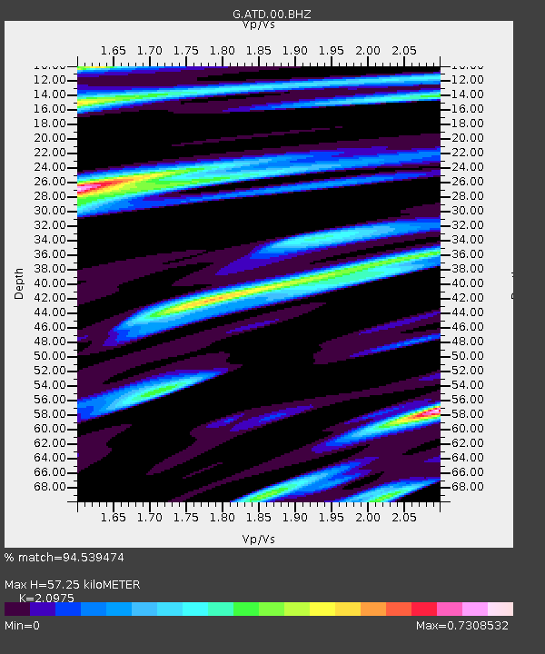
| Estimated Moho Depth: |
57.25 km |
| Estimated Crust Vp/Vs: |
2.10 |
| Assumed Crust Vp: |
6.375 km/s |
| Estimated Crust Vs: |
3.039 km/s |
| Estimated Crust Poisson's Ratio: |
0.35 |
|
| Radial Match: |
94.539474 % |
| Radial Bump: |
400 |
| Transverse Match: |
86.61671 % |
| Transverse Bump: |
400 |
| SOD ConfigId: |
28764291 |
| Insert Time: |
2022-10-07 21:00:57.330 +0000 |
| GWidth: |
2.5 |
| Max Bumps: |
400 |
| Tol: |
0.001 |
|

Signal To Noise
| Channel | StoN | STA | LTA |
| G:ATD:00:BHZ:20220923T21:01:41.599981Z | 2.55466 | 1.6399478E-7 | 6.419437E-8 |
| G:ATD:00:BHN:20220923T21:01:41.599981Z | 1.3055706 | 7.3483065E-8 | 5.6284254E-8 |
| G:ATD:00:BHE:20220923T21:01:41.599981Z | 1.3187551 | 1.0423964E-7 | 7.9043964E-8 |
| Arrivals |
| Ps | 10 SECOND |
| PpPs | 27 SECOND |
| PsPs/PpSs | 37 SECOND |


