You are here: Home > Network List > JP - Japan Meteorological Agency Seismic Network Stations List
> Station JMM Miyagi Marumori > Earthquake Result Viewer
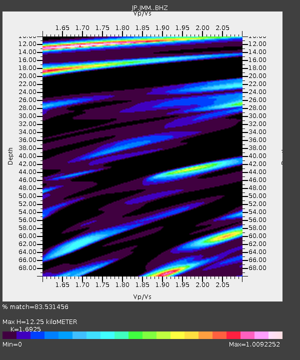
JMM Miyagi Marumori - Earthquake Result Viewer
| Earthquake location: |
Off W Coast Of Northern Sumatra |
| Earthquake latitude/longitude: |
3.8/96.0 |
| Earthquake time(UTC): |
2022/09/23 (266) 20:52:59 GMT |
| Earthquake Depth: |
49 km |
| Earthquake Magnitude: |
6.2 mww |
| Earthquake Catalog/Contributor: |
NEIC PDE/us |
|
| Network: |
JP Japan Meteorological Agency Seismic Network |
| Station: |
JMM Miyagi Marumori |
| Lat/Lon: |
37.87 N/140.79 E |
| Elevation: |
100 m |
|
| Distance: |
53.1 deg |
| Az: |
44.229 deg |
| Baz: |
241.576 deg |
| Ray Param: |
0.06623074 |
| Estimated Moho Depth: |
12.25 km |
| Estimated Crust Vp/Vs: |
1.69 |
| Assumed Crust Vp: |
6.24 km/s |
| Estimated Crust Vs: |
3.687 km/s |
| Estimated Crust Poisson's Ratio: |
0.23 |
|
| Radial Match: |
83.531456 % |
| Radial Bump: |
400 |
| Transverse Match: |
69.08496 % |
| Transverse Bump: |
400 |
| SOD ConfigId: |
28764291 |
| Insert Time: |
2022-10-07 21:03:39.865 +0000 |
| GWidth: |
2.5 |
| Max Bumps: |
400 |
| Tol: |
0.001 |
|

Signal To Noise
| Channel | StoN | STA | LTA |
| JP:JMM: :BHZ:20220923T21:01:41.099981Z | 2.6337876 | 2.9383384E-7 | 1.11563224E-7 |
| JP:JMM: :BHN:20220923T21:01:41.099981Z | 1.1920235 | 1.1018633E-7 | 9.2436366E-8 |
| JP:JMM: :BHE:20220923T21:01:41.099981Z | 1.2665671 | 1.648832E-7 | 1.3018118E-7 |
| Arrivals |
| Ps | 1.4 SECOND |
| PpPs | 5.0 SECOND |
| PsPs/PpSs | 6.4 SECOND |


