You are here: Home > Network List > XA95 - Missouri to Massachusetts Transect Stations List
> Station MM04 LeRaysville, Pennsylvania > Earthquake Result Viewer
MM04 LeRaysville, Pennsylvania - Earthquake Result Viewer
| Earthquake location: |
Gulf Of California |
| Earthquake latitude/longitude: |
26.2/-110.3 |
| Earthquake time(UTC): |
1995/08/28 (240) 10:46:12 GMT |
| Earthquake Depth: |
10 km |
| Earthquake Magnitude: |
5.6 MB, 6.5 MS |
| Earthquake Catalog/Contributor: |
WHDF/NEIC |
|
| Network: |
XA Missouri to Massachusetts Transect |
| Station: |
MM04 LeRaysville, Pennsylvania |
| Lat/Lon: |
41.85 N/76.20 W |
| Elevation: |
473 m |
|
| Distance: |
32.1 deg |
| Az: |
52.112 deg |
| Baz: |
251.702 deg |
| Ray Param: |
0.0787953 |
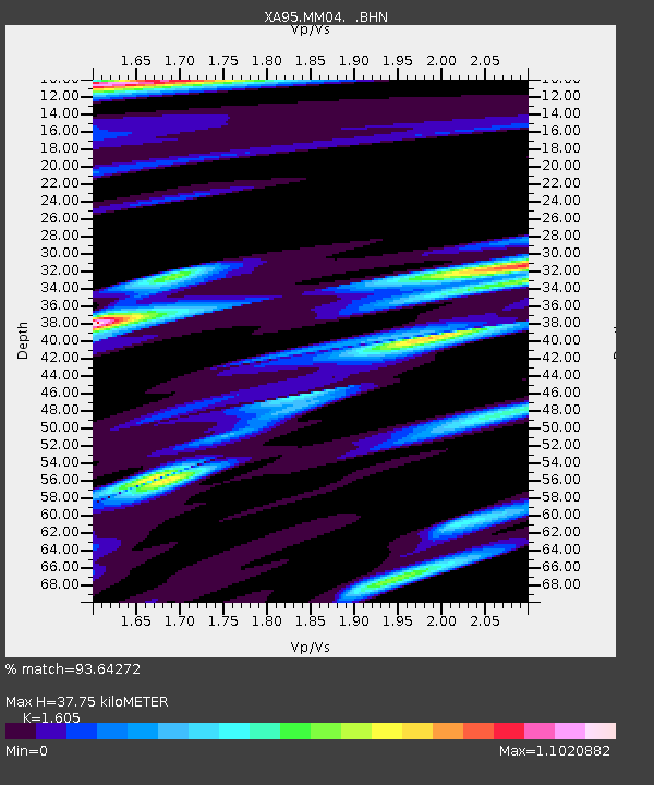
| Estimated Moho Depth: |
37.75 km |
| Estimated Crust Vp/Vs: |
1.61 |
| Assumed Crust Vp: |
6.121 km/s |
| Estimated Crust Vs: |
3.813 km/s |
| Estimated Crust Poisson's Ratio: |
0.18 |
|
| Radial Match: |
93.64272 % |
| Radial Bump: |
263 |
| Transverse Match: |
90.22973 % |
| Transverse Bump: |
288 |
| SOD ConfigId: |
6273 |
| Insert Time: |
2010-02-26 17:45:05.281 +0000 |
| GWidth: |
2.5 |
| Max Bumps: |
400 |
| Tol: |
0.001 |
|

Signal To Noise
| Channel | StoN | STA | LTA |
| XA:MM04: :BHN:19950828T10:52:09.414008Z | 0.7841706 | 1.2394122E-7 | 1.5805391E-7 |
| XA:MM04: :BHE:19950828T10:52:09.413Z | 3.8630502 | 7.9422415E-7 | 2.0559509E-7 |
| XA:MM04: :BHZ:19950828T10:52:09.414008Z | 2.2203634 | 4.8744096E-7 | 2.1953207E-7 |
| Arrivals |
| Ps | 4.0 SECOND |
| PpPs | 15 SECOND |
| PsPs/PpSs | 19 SECOND |


