You are here: Home > Network List > XA95 - Missouri to Massachusetts Transect Stations List
> Station MM04 LeRaysville, Pennsylvania > Earthquake Result Viewer
MM04 LeRaysville, Pennsylvania - Earthquake Result Viewer
| Earthquake location: |
Near Coast Of Guatemala |
| Earthquake latitude/longitude: |
13.0/-91.1 |
| Earthquake time(UTC): |
1996/02/25 (056) 14:17:21 GMT |
| Earthquake Depth: |
33 km |
| Earthquake Magnitude: |
5.5 MB, 5.2 MS, 5.9 UNKNOWN, 5.8 MW |
| Earthquake Catalog/Contributor: |
WHDF/NEIC |
|
| Network: |
XA Missouri to Massachusetts Transect |
| Station: |
MM04 LeRaysville, Pennsylvania |
| Lat/Lon: |
41.85 N/76.20 W |
| Elevation: |
473 m |
|
| Distance: |
31.5 deg |
| Az: |
21.498 deg |
| Baz: |
208.561 deg |
| Ray Param: |
0.07899978 |
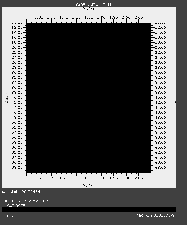
| Estimated Moho Depth: |
69.75 km |
| Estimated Crust Vp/Vs: |
2.10 |
| Assumed Crust Vp: |
6.121 km/s |
| Estimated Crust Vs: |
2.918 km/s |
| Estimated Crust Poisson's Ratio: |
0.35 |
|
| Radial Match: |
99.87454 % |
| Radial Bump: |
32 |
| Transverse Match: |
99.87583 % |
| Transverse Bump: |
32 |
| SOD ConfigId: |
29242 |
| Insert Time: |
2010-02-26 17:45:07.443 +0000 |
| GWidth: |
2.5 |
| Max Bumps: |
400 |
| Tol: |
0.001 |
|
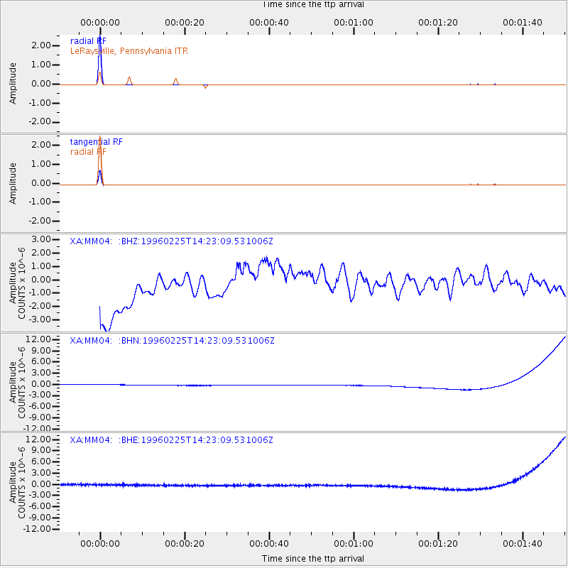
Signal To Noise
| Channel | StoN | STA | LTA |
| XA:MM04: :BHN:19960225T14:23:09.531006Z | 0.9455327 | 1.0000966E-6 | 1.0577071E-6 |
| XA:MM04: :BHE:19960225T14:23:09.531006Z | 0.9286999 | 9.848328E-7 | 1.0604425E-6 |
| XA:MM04: :BHZ:19960225T14:23:09.531006Z | 1.3080195 | 1.6035023E-6 | 1.2259009E-6 |
| Arrivals |
| Ps | 13 SECOND |
| PpPs | 33 SECOND |
| PsPs/PpSs | 47 SECOND |


