You are here: Home > Network List > AE - Arizona Broadband Seismic Network Stations List
> Station TONTO Roosevelt/Tonto Basin > Earthquake Result Viewer
TONTO Roosevelt/Tonto Basin - Earthquake Result Viewer
| Earthquake location: |
Reykjanes Ridge |
| Earthquake latitude/longitude: |
54.0/-35.2 |
| Earthquake time(UTC): |
2022/09/26 (269) 09:59:56 GMT |
| Earthquake Depth: |
10 km |
| Earthquake Magnitude: |
5.7 mww |
| Earthquake Catalog/Contributor: |
NEIC PDE/us |
|
| Network: |
AE Arizona Broadband Seismic Network |
| Station: |
TONTO Roosevelt/Tonto Basin |
| Lat/Lon: |
33.65 N/111.01 W |
| Elevation: |
661 m |
|
| Distance: |
55.5 deg |
| Az: |
281.198 deg |
| Baz: |
43.963 deg |
| Ray Param: |
0.064741105 |
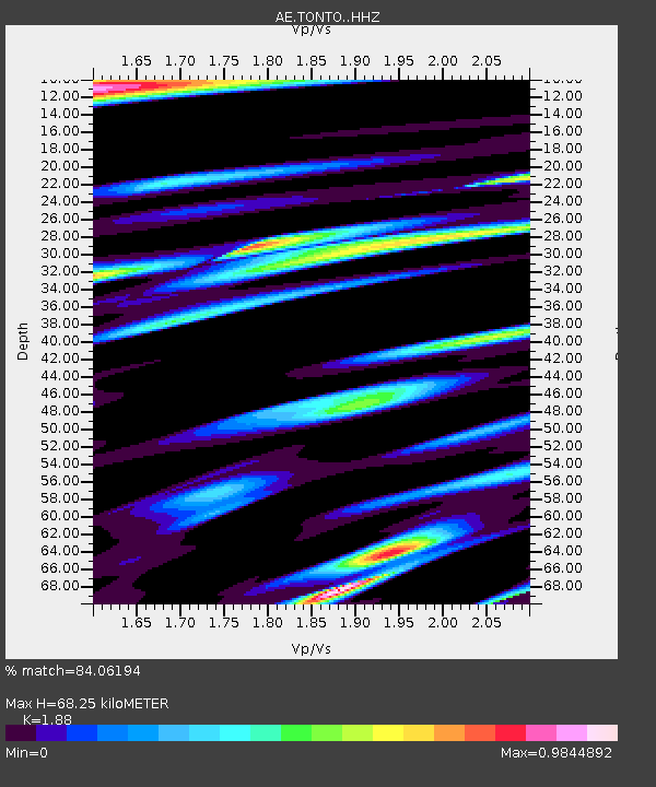
| Estimated Moho Depth: |
68.25 km |
| Estimated Crust Vp/Vs: |
1.88 |
| Assumed Crust Vp: |
6.276 km/s |
| Estimated Crust Vs: |
3.338 km/s |
| Estimated Crust Poisson's Ratio: |
0.30 |
|
| Radial Match: |
84.06194 % |
| Radial Bump: |
400 |
| Transverse Match: |
65.23485 % |
| Transverse Bump: |
400 |
| SOD ConfigId: |
28764291 |
| Insert Time: |
2022-10-10 10:02:16.650 +0000 |
| GWidth: |
2.5 |
| Max Bumps: |
400 |
| Tol: |
0.001 |
|

Signal To Noise
| Channel | StoN | STA | LTA |
| AE:TONTO: :HHZ:20220926T10:09:00.489026Z | 4.0379577 | 3.5271157E-7 | 8.7348994E-8 |
| AE:TONTO: :HHN:20220926T10:09:00.489026Z | 1.3989762 | 1.5132231E-7 | 1.0816646E-7 |
| AE:TONTO: :HHE:20220926T10:09:00.489026Z | 1.0927925 | 1.4816655E-7 | 1.3558525E-7 |
| Arrivals |
| Ps | 10 SECOND |
| PpPs | 30 SECOND |
| PsPs/PpSs | 40 SECOND |


