You are here: Home > Network List > N4 - Central and EAstern US Network Stations List
> Station Y52A Lilburn, GA, USA > Earthquake Result Viewer
Y52A Lilburn, GA, USA - Earthquake Result Viewer
| Earthquake location: |
Reykjanes Ridge |
| Earthquake latitude/longitude: |
54.0/-35.2 |
| Earthquake time(UTC): |
2022/09/26 (269) 09:59:56 GMT |
| Earthquake Depth: |
10 km |
| Earthquake Magnitude: |
5.7 mww |
| Earthquake Catalog/Contributor: |
NEIC PDE/us |
|
| Network: |
N4 Central and EAstern US Network |
| Station: |
Y52A Lilburn, GA, USA |
| Lat/Lon: |
33.86 N/84.06 W |
| Elevation: |
286 m |
|
| Distance: |
39.6 deg |
| Az: |
259.617 deg |
| Baz: |
44.251 deg |
| Ray Param: |
0.074924976 |
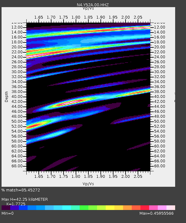
| Estimated Moho Depth: |
42.25 km |
| Estimated Crust Vp/Vs: |
1.77 |
| Assumed Crust Vp: |
6.719 km/s |
| Estimated Crust Vs: |
3.791 km/s |
| Estimated Crust Poisson's Ratio: |
0.27 |
|
| Radial Match: |
85.45272 % |
| Radial Bump: |
400 |
| Transverse Match: |
60.048496 % |
| Transverse Bump: |
400 |
| SOD ConfigId: |
28764291 |
| Insert Time: |
2022-10-10 10:20:49.059 +0000 |
| GWidth: |
2.5 |
| Max Bumps: |
400 |
| Tol: |
0.001 |
|

Signal To Noise
| Channel | StoN | STA | LTA |
| N4:Y52A:00:HHZ:20220926T10:06:56.63899Z | 2.384835 | 3.7207502E-7 | 1.560171E-7 |
| N4:Y52A:00:HH1:20220926T10:06:56.63899Z | 2.8906326 | 2.7619095E-7 | 9.554689E-8 |
| N4:Y52A:00:HH2:20220926T10:06:56.63899Z | 0.9988672 | 1.5328813E-7 | 1.5346197E-7 |
| Arrivals |
| Ps | 5.3 SECOND |
| PpPs | 16 SECOND |
| PsPs/PpSs | 21 SECOND |


