You are here: Home > Network List > TX - Texas Seismological Network Stations List
> Station PB05 Z > Earthquake Result Viewer
PB05 Z - Earthquake Result Viewer
| Earthquake location: |
Reykjanes Ridge |
| Earthquake latitude/longitude: |
54.0/-35.2 |
| Earthquake time(UTC): |
2022/09/26 (269) 09:59:56 GMT |
| Earthquake Depth: |
10 km |
| Earthquake Magnitude: |
5.7 mww |
| Earthquake Catalog/Contributor: |
NEIC PDE/us |
|
| Network: |
TX Texas Seismological Network |
| Station: |
PB05 Z |
| Lat/Lon: |
30.92 N/103.32 W |
| Elevation: |
957 m |
|
| Distance: |
53.0 deg |
| Az: |
273.084 deg |
| Baz: |
43.305 deg |
| Ray Param: |
0.06641389 |
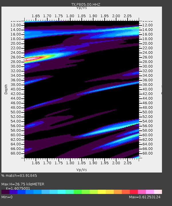
| Estimated Moho Depth: |
26.75 km |
| Estimated Crust Vp/Vs: |
1.61 |
| Assumed Crust Vp: |
6.121 km/s |
| Estimated Crust Vs: |
3.807 km/s |
| Estimated Crust Poisson's Ratio: |
0.18 |
|
| Radial Match: |
83.91845 % |
| Radial Bump: |
400 |
| Transverse Match: |
55.4443 % |
| Transverse Bump: |
400 |
| SOD ConfigId: |
28764291 |
| Insert Time: |
2022-10-10 10:28:49.528 +0000 |
| GWidth: |
2.5 |
| Max Bumps: |
400 |
| Tol: |
0.001 |
|

Signal To Noise
| Channel | StoN | STA | LTA |
| TX:PB05:00:HHZ:20220926T10:08:42.099988Z | 2.3010056 | 3.5884733E-7 | 1.5595239E-7 |
| TX:PB05:00:HH1:20220926T10:08:42.099988Z | 1.3288275 | 1.1636423E-7 | 8.7569106E-8 |
| TX:PB05:00:HH2:20220926T10:08:42.099988Z | 2.004801 | 1.8035944E-7 | 8.9963756E-8 |
| Arrivals |
| Ps | 2.8 SECOND |
| PpPs | 11 SECOND |
| PsPs/PpSs | 14 SECOND |


