You are here: Home > Network List > TX - Texas Seismological Network Stations List
> Station PH02 Texas Public Hunt System CROSS BAR MGT AREA > Earthquake Result Viewer
PH02 Texas Public Hunt System CROSS BAR MGT AREA - Earthquake Result Viewer
| Earthquake location: |
Reykjanes Ridge |
| Earthquake latitude/longitude: |
54.0/-35.2 |
| Earthquake time(UTC): |
2022/09/26 (269) 09:59:56 GMT |
| Earthquake Depth: |
10 km |
| Earthquake Magnitude: |
5.7 mww |
| Earthquake Catalog/Contributor: |
NEIC PDE/us |
|
| Network: |
TX Texas Seismological Network |
| Station: |
PH02 Texas Public Hunt System CROSS BAR MGT AREA |
| Lat/Lon: |
35.39 N/101.95 W |
| Elevation: |
1022 m |
|
| Distance: |
49.0 deg |
| Az: |
276.055 deg |
| Baz: |
45.927 deg |
| Ray Param: |
0.068992496 |
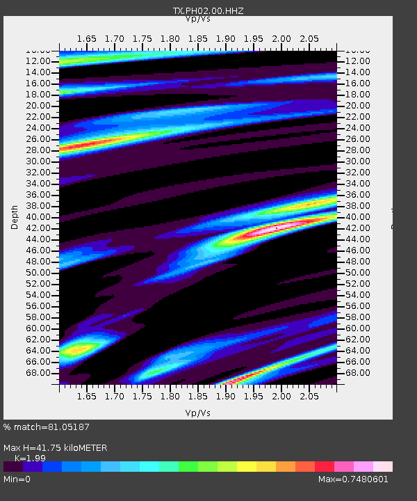
| Estimated Moho Depth: |
41.75 km |
| Estimated Crust Vp/Vs: |
1.99 |
| Assumed Crust Vp: |
6.426 km/s |
| Estimated Crust Vs: |
3.229 km/s |
| Estimated Crust Poisson's Ratio: |
0.33 |
|
| Radial Match: |
81.05187 % |
| Radial Bump: |
393 |
| Transverse Match: |
74.10264 % |
| Transverse Bump: |
400 |
| SOD ConfigId: |
28764291 |
| Insert Time: |
2022-10-10 10:29:06.602 +0000 |
| GWidth: |
2.5 |
| Max Bumps: |
400 |
| Tol: |
0.001 |
|

Signal To Noise
| Channel | StoN | STA | LTA |
| TX:PH02:00:HHZ:20220926T10:08:12.159986Z | 2.8922148 | 4.089616E-7 | 1.4140085E-7 |
| TX:PH02:00:HH1:20220926T10:08:12.159986Z | 1.8521955 | 2.8784007E-7 | 1.5540479E-7 |
| TX:PH02:00:HH2:20220926T10:08:12.159986Z | 1.8015813 | 1.8823404E-7 | 1.0448269E-7 |
| Arrivals |
| Ps | 6.8 SECOND |
| PpPs | 18 SECOND |
| PsPs/PpSs | 25 SECOND |


