You are here: Home > Network List > TX - Texas Seismological Network Stations List
> Station SN03 Snyder 3 > Earthquake Result Viewer
SN03 Snyder 3 - Earthquake Result Viewer
| Earthquake location: |
Reykjanes Ridge |
| Earthquake latitude/longitude: |
54.0/-35.2 |
| Earthquake time(UTC): |
2022/09/26 (269) 09:59:56 GMT |
| Earthquake Depth: |
10 km |
| Earthquake Magnitude: |
5.7 mww |
| Earthquake Catalog/Contributor: |
NEIC PDE/us |
|
| Network: |
TX Texas Seismological Network |
| Station: |
SN03 Snyder 3 |
| Lat/Lon: |
32.92 N/100.94 W |
| Elevation: |
744 m |
|
| Distance: |
50.1 deg |
| Az: |
272.988 deg |
| Baz: |
44.5 deg |
| Ray Param: |
0.068255074 |
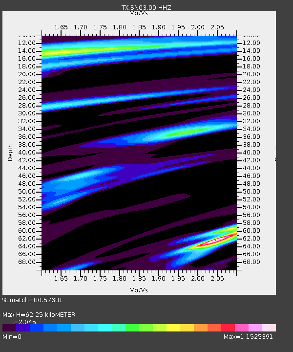
| Estimated Moho Depth: |
62.25 km |
| Estimated Crust Vp/Vs: |
2.05 |
| Assumed Crust Vp: |
6.426 km/s |
| Estimated Crust Vs: |
3.142 km/s |
| Estimated Crust Poisson's Ratio: |
0.34 |
|
| Radial Match: |
80.57681 % |
| Radial Bump: |
285 |
| Transverse Match: |
53.354225 % |
| Transverse Bump: |
351 |
| SOD ConfigId: |
28764291 |
| Insert Time: |
2022-10-10 10:29:18.927 +0000 |
| GWidth: |
2.5 |
| Max Bumps: |
400 |
| Tol: |
0.001 |
|
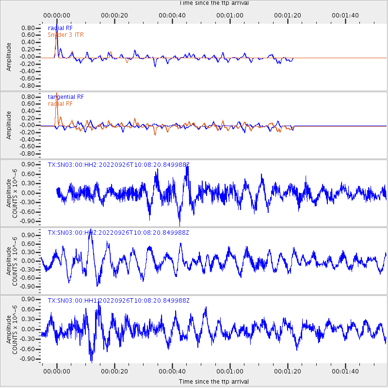
Signal To Noise
| Channel | StoN | STA | LTA |
| TX:SN03:00:HHZ:20220926T10:08:20.849988Z | 2.773963 | 3.5584014E-7 | 1.2827863E-7 |
| TX:SN03:00:HH1:20220926T10:08:20.849988Z | 1.2827486 | 1.5721895E-7 | 1.2256412E-7 |
| TX:SN03:00:HH2:20220926T10:08:20.849988Z | 2.1991282 | 3.3020345E-7 | 1.5015199E-7 |
| Arrivals |
| Ps | 11 SECOND |
| PpPs | 28 SECOND |
| PsPs/PpSs | 39 SECOND |


