You are here: Home > Network List > US - United States National Seismic Network Stations List
> Station HAWA Hanford, Washington, USA > Earthquake Result Viewer
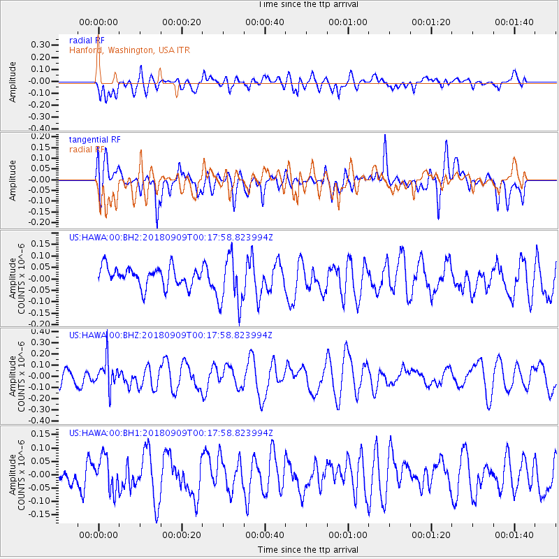
HAWA Hanford, Washington, USA - Earthquake Result Viewer
*The percent match for this event was below the threshold and hence no stack was calculated.
| Earthquake location: |
South Of Fiji Islands |
| Earthquake latitude/longitude: |
-25.0/179.9 |
| Earthquake time(UTC): |
2018/09/09 (252) 00:06:23 GMT |
| Earthquake Depth: |
479 km |
| Earthquake Magnitude: |
5.5 Mww |
| Earthquake Catalog/Contributor: |
NEIC PDE/us |
|
| Network: |
US United States National Seismic Network |
| Station: |
HAWA Hanford, Washington, USA |
| Lat/Lon: |
46.39 N/119.53 W |
| Elevation: |
364 m |
|
| Distance: |
89.7 deg |
| Az: |
37.053 deg |
| Baz: |
232.169 deg |
| Ray Param: |
$rayparam |
*The percent match for this event was below the threshold and hence was not used in the summary stack. |
|
| Radial Match: |
43.762432 % |
| Radial Bump: |
400 |
| Transverse Match: |
40.63736 % |
| Transverse Bump: |
400 |
| SOD ConfigId: |
2825771 |
| Insert Time: |
2018-09-23 00:14:00.182 +0000 |
| GWidth: |
2.5 |
| Max Bumps: |
400 |
| Tol: |
0.001 |
|
Signal To Noise
| Channel | StoN | STA | LTA |
| US:HAWA:00:BHZ:20180909T00:17:58.823994Z | 1.7566496 | 1.3005702E-7 | 7.4036976E-8 |
| US:HAWA:00:BH1:20180909T00:17:58.823994Z | 1.1574901 | 6.416118E-8 | 5.5431297E-8 |
| US:HAWA:00:BH2:20180909T00:17:58.823994Z | 2.6833045 | 1.1089333E-7 | 4.132715E-8 |
| Arrivals |
| Ps | |
| PpPs | |
| PsPs/PpSs | |


