You are here: Home > Network List > XA95 - Missouri to Massachusetts Transect Stations List
> Station MM04 LeRaysville, Pennsylvania > Earthquake Result Viewer
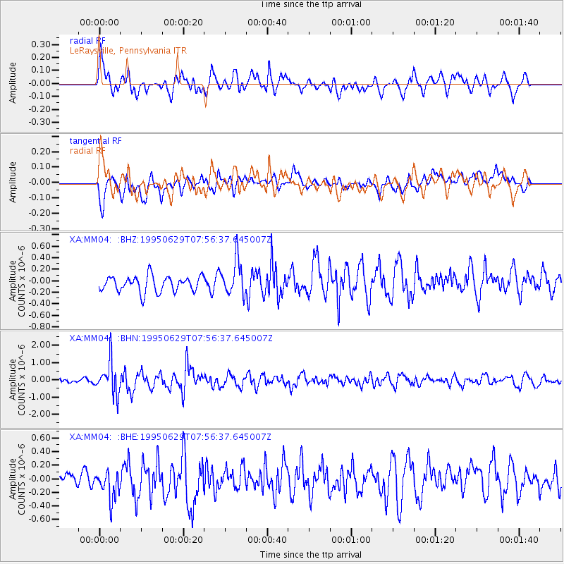
MM04 LeRaysville, Pennsylvania - Earthquake Result Viewer
*The percent match for this event was below the threshold and hence no stack was calculated.
| Earthquake location: |
Kuril Islands |
| Earthquake latitude/longitude: |
48.8/154.5 |
| Earthquake time(UTC): |
1995/06/29 (180) 07:45:09 GMT |
| Earthquake Depth: |
62 km |
| Earthquake Magnitude: |
5.9 MB, 6.0 UNKNOWN, 6.0 MW |
| Earthquake Catalog/Contributor: |
WHDF/NEIC |
|
| Network: |
XA Missouri to Massachusetts Transect |
| Station: |
MM04 LeRaysville, Pennsylvania |
| Lat/Lon: |
41.85 N/76.20 W |
| Elevation: |
473 m |
|
| Distance: |
79.3 deg |
| Az: |
36.012 deg |
| Baz: |
328.633 deg |
| Ray Param: |
$rayparam |
*The percent match for this event was below the threshold and hence was not used in the summary stack. |
|
| Radial Match: |
62.505383 % |
| Radial Bump: |
400 |
| Transverse Match: |
61.072865 % |
| Transverse Bump: |
400 |
| SOD ConfigId: |
4480 |
| Insert Time: |
2010-02-26 17:45:25.351 +0000 |
| GWidth: |
2.5 |
| Max Bumps: |
400 |
| Tol: |
0.001 |
|
Signal To Noise
| Channel | StoN | STA | LTA |
| XA:MM04: :BHN:19950629T07:56:37.645007Z | 4.29296 | 9.701082E-7 | 2.2597652E-7 |
| XA:MM04: :BHE:19950629T07:56:37.645007Z | 1.550501 | 2.2066118E-7 | 1.4231605E-7 |
| XA:MM04: :BHZ:19950629T07:56:37.645007Z | 2.316884 | 3.159228E-7 | 1.3635675E-7 |
| Arrivals |
| Ps | |
| PpPs | |
| PsPs/PpSs | |


