You are here: Home > Network List > XA95 - Missouri to Massachusetts Transect Stations List
> Station MM04 LeRaysville, Pennsylvania > Earthquake Result Viewer
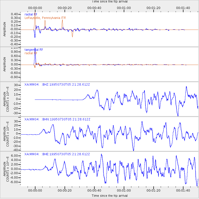
MM04 LeRaysville, Pennsylvania - Earthquake Result Viewer
*The percent match for this event was below the threshold and hence no stack was calculated.
| Earthquake location: |
Near Coast Of Northern Chile |
| Earthquake latitude/longitude: |
-23.4/-70.3 |
| Earthquake time(UTC): |
1995/07/30 (211) 05:11:23 GMT |
| Earthquake Depth: |
47 km |
| Earthquake Magnitude: |
6.6 MB, 7.3 MS, 7.2 UNKNOWN, 8.1 MW |
| Earthquake Catalog/Contributor: |
WHDF/NEIC |
|
| Network: |
XA Missouri to Massachusetts Transect |
| Station: |
MM04 LeRaysville, Pennsylvania |
| Lat/Lon: |
41.85 N/76.20 W |
| Elevation: |
473 m |
|
| Distance: |
65.1 deg |
| Az: |
355.155 deg |
| Baz: |
174.037 deg |
| Ray Param: |
$rayparam |
*The percent match for this event was below the threshold and hence was not used in the summary stack. |
|
| Radial Match: |
97.26386 % |
| Radial Bump: |
400 |
| Transverse Match: |
99.772026 % |
| Transverse Bump: |
76 |
| SOD ConfigId: |
4480 |
| Insert Time: |
2010-02-26 17:45:25.790 +0000 |
| GWidth: |
2.5 |
| Max Bumps: |
400 |
| Tol: |
0.001 |
|
Signal To Noise
| Channel | StoN | STA | LTA |
| XA:MM04: :BHN:19950730T05:21:28.612Z | 10.413259 | 2.785625E-6 | 2.6750752E-7 |
| XA:MM04: :BHE:19950730T05:21:28.612Z | 1.838248 | 1.6779006E-7 | 9.127716E-8 |
| XA:MM04: :BHZ:19950730T05:21:28.612Z | 10.4207325 | 2.4055614E-6 | 2.3084378E-7 |
| Arrivals |
| Ps | |
| PpPs | |
| PsPs/PpSs | |


