You are here: Home > Network List > G - GEOSCOPE Stations List
> Station MPG Montagne des Peres, French Guyana > Earthquake Result Viewer
MPG Montagne des Peres, French Guyana - Earthquake Result Viewer
| Earthquake location: |
East Of South Sandwich Islands |
| Earthquake latitude/longitude: |
-60.6/-20.0 |
| Earthquake time(UTC): |
2022/09/29 (272) 03:03:29 GMT |
| Earthquake Depth: |
33 km |
| Earthquake Magnitude: |
6.7 Mi |
| Earthquake Catalog/Contributor: |
NEIC PDE/at |
|
| Network: |
G GEOSCOPE |
| Station: |
MPG Montagne des Peres, French Guyana |
| Lat/Lon: |
5.11 N/52.64 W |
| Elevation: |
147 m |
|
| Distance: |
70.3 deg |
| Az: |
325.204 deg |
| Baz: |
163.58 deg |
| Ray Param: |
0.055032495 |
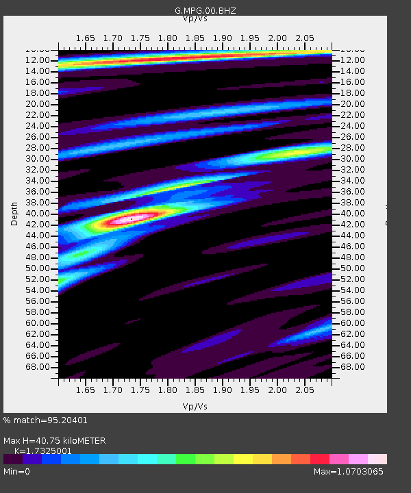
| Estimated Moho Depth: |
40.75 km |
| Estimated Crust Vp/Vs: |
1.73 |
| Assumed Crust Vp: |
6.472 km/s |
| Estimated Crust Vs: |
3.736 km/s |
| Estimated Crust Poisson's Ratio: |
0.25 |
|
| Radial Match: |
95.20401 % |
| Radial Bump: |
277 |
| Transverse Match: |
74.96315 % |
| Transverse Bump: |
400 |
| SOD ConfigId: |
28764291 |
| Insert Time: |
2022-10-13 03:08:56.685 +0000 |
| GWidth: |
2.5 |
| Max Bumps: |
400 |
| Tol: |
0.001 |
|

Signal To Noise
| Channel | StoN | STA | LTA |
| G:MPG:00:BHZ:20220929T03:14:08.299011Z | 8.650913 | 8.1277005E-7 | 9.395194E-8 |
| G:MPG:00:BHN:20220929T03:14:08.299011Z | 5.5673685 | 3.2968262E-7 | 5.9216955E-8 |
| G:MPG:00:BHE:20220929T03:14:08.299011Z | 2.7004092 | 2.371857E-7 | 8.783325E-8 |
| Arrivals |
| Ps | 4.8 SECOND |
| PpPs | 17 SECOND |
| PsPs/PpSs | 21 SECOND |


