You are here: Home > Network List > G - GEOSCOPE Stations List
> Station TAM Tamanrasset, Algeria > Earthquake Result Viewer
TAM Tamanrasset, Algeria - Earthquake Result Viewer

| Earthquake location: |
East Of South Sandwich Islands |
| Earthquake latitude/longitude: |
-60.6/-20.0 |
| Earthquake time(UTC): |
2022/09/29 (272) 03:03:29 GMT |
| Earthquake Depth: |
33 km |
| Earthquake Magnitude: |
6.7 Mi |
| Earthquake Catalog/Contributor: |
NEIC PDE/at |
|
| Network: |
G GEOSCOPE |
| Station: |
TAM Tamanrasset, Algeria |
| Lat/Lon: |
22.79 N/5.53 E |
| Elevation: |
1377 m |
|
| Distance: |
85.6 deg |
| Az: |
23.506 deg |
| Baz: |
192.312 deg |
| Ray Param: |
0.044571843 |
| Estimated Moho Depth: |
36.25 km |
| Estimated Crust Vp/Vs: |
1.72 |
| Assumed Crust Vp: |
6.61 km/s |
| Estimated Crust Vs: |
3.843 km/s |
| Estimated Crust Poisson's Ratio: |
0.24 |
|
| Radial Match: |
97.71729 % |
| Radial Bump: |
270 |
| Transverse Match: |
82.11695 % |
| Transverse Bump: |
400 |
| SOD ConfigId: |
28764291 |
| Insert Time: |
2022-10-13 03:09:02.355 +0000 |
| GWidth: |
2.5 |
| Max Bumps: |
400 |
| Tol: |
0.001 |
|
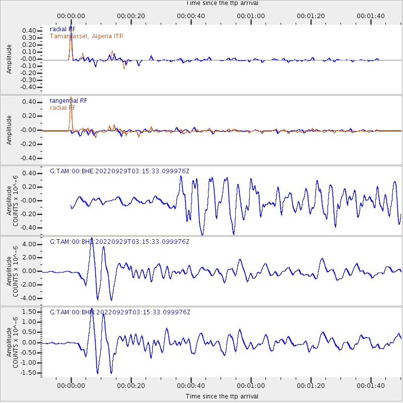
Signal To Noise
| Channel | StoN | STA | LTA |
| G:TAM:00:BHZ:20220929T03:15:33.099976Z | 17.333267 | 7.042947E-7 | 4.0632543E-8 |
| G:TAM:00:BHN:20220929T03:15:33.099976Z | 8.133211 | 2.3075546E-7 | 2.8372E-8 |
| G:TAM:00:BHE:20220929T03:15:33.099976Z | 1.4278094 | 5.892501E-8 | 4.1269523E-8 |
| Arrivals |
| Ps | 4.1 SECOND |
| PpPs | 15 SECOND |
| PsPs/PpSs | 19 SECOND |


