You are here: Home > Network List > WI - West Indies IPGP Network Stations List
> Station BIM Morne Bigot, Anses d'Arlets, Martinique > Earthquake Result Viewer
BIM Morne Bigot, Anses d'Arlets, Martinique - Earthquake Result Viewer
| Earthquake location: |
East Of South Sandwich Islands |
| Earthquake latitude/longitude: |
-60.6/-20.0 |
| Earthquake time(UTC): |
2022/09/29 (272) 03:03:29 GMT |
| Earthquake Depth: |
33 km |
| Earthquake Magnitude: |
6.7 Mi |
| Earthquake Catalog/Contributor: |
NEIC PDE/at |
|
| Network: |
WI West Indies IPGP Network |
| Station: |
BIM Morne Bigot, Anses d'Arlets, Martinique |
| Lat/Lon: |
14.52 N/61.07 W |
| Elevation: |
391 m |
|
| Distance: |
81.7 deg |
| Az: |
319.993 deg |
| Baz: |
160.881 deg |
| Ray Param: |
0.047331363 |
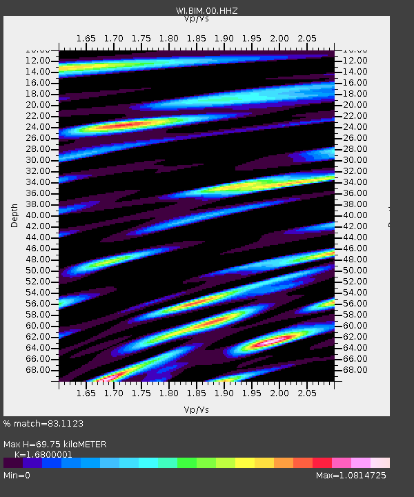
| Estimated Moho Depth: |
69.75 km |
| Estimated Crust Vp/Vs: |
1.68 |
| Assumed Crust Vp: |
5.88 km/s |
| Estimated Crust Vs: |
3.5 km/s |
| Estimated Crust Poisson's Ratio: |
0.23 |
|
| Radial Match: |
83.1123 % |
| Radial Bump: |
400 |
| Transverse Match: |
79.570244 % |
| Transverse Bump: |
400 |
| SOD ConfigId: |
28764291 |
| Insert Time: |
2022-10-13 03:13:10.885 +0000 |
| GWidth: |
2.5 |
| Max Bumps: |
400 |
| Tol: |
0.001 |
|

Signal To Noise
| Channel | StoN | STA | LTA |
| WI:BIM:00:HHZ:20220929T03:15:13.179993Z | 4.714784 | 1.3335447E-6 | 2.8284322E-7 |
| WI:BIM:00:HHN:20220929T03:15:13.179993Z | 1.9470068 | 7.499589E-7 | 3.8518553E-7 |
| WI:BIM:00:HHE:20220929T03:15:13.179993Z | 1.1535058 | 4.8165106E-7 | 4.1755413E-7 |
| Arrivals |
| Ps | 8.3 SECOND |
| PpPs | 31 SECOND |
| PsPs/PpSs | 39 SECOND |


