You are here: Home > Network List > XA95 - Missouri to Massachusetts Transect Stations List
> Station MM04 LeRaysville, Pennsylvania > Earthquake Result Viewer
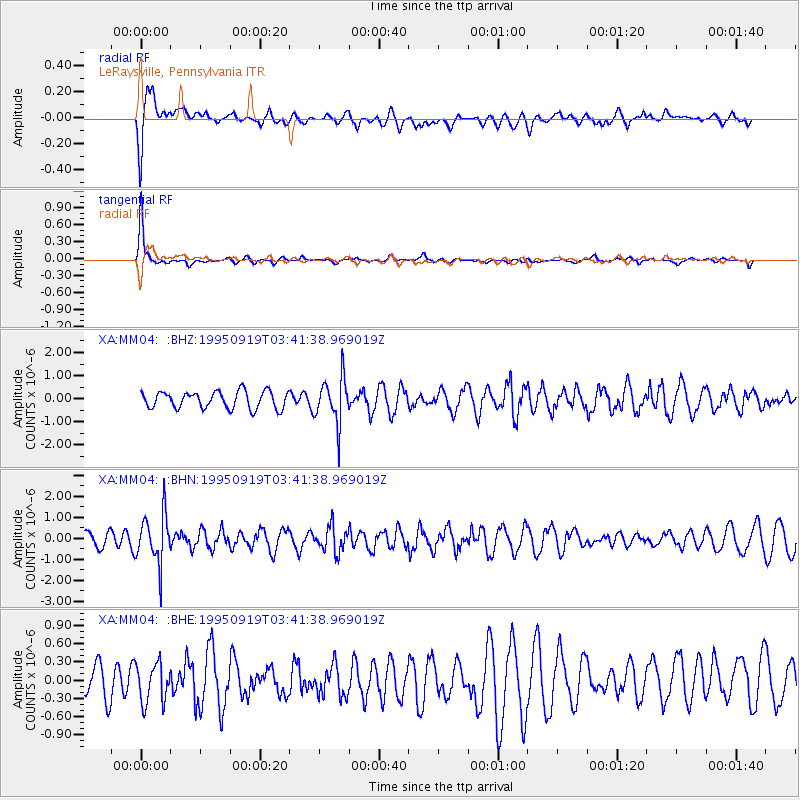
MM04 LeRaysville, Pennsylvania - Earthquake Result Viewer
*The percent match for this event was below the threshold and hence no stack was calculated.
| Earthquake location: |
Chile-Bolivia Border Region |
| Earthquake latitude/longitude: |
-21.2/-68.7 |
| Earthquake time(UTC): |
1995/09/19 (262) 03:31:53 GMT |
| Earthquake Depth: |
110 km |
| Earthquake Magnitude: |
5.7 MB, 5.7 UNKNOWN, 5.6 MW |
| Earthquake Catalog/Contributor: |
WHDF/NEIC |
|
| Network: |
XA Missouri to Massachusetts Transect |
| Station: |
MM04 LeRaysville, Pennsylvania |
| Lat/Lon: |
41.85 N/76.20 W |
| Elevation: |
473 m |
|
| Distance: |
63.1 deg |
| Az: |
353.76 deg |
| Baz: |
172.198 deg |
| Ray Param: |
$rayparam |
*The percent match for this event was below the threshold and hence was not used in the summary stack. |
|
| Radial Match: |
83.60938 % |
| Radial Bump: |
400 |
| Transverse Match: |
92.89577 % |
| Transverse Bump: |
321 |
| SOD ConfigId: |
4480 |
| Insert Time: |
2010-02-26 17:45:31.572 +0000 |
| GWidth: |
2.5 |
| Max Bumps: |
400 |
| Tol: |
0.001 |
|
Signal To Noise
| Channel | StoN | STA | LTA |
| XA:MM04: :BHN:19950919T03:41:38.969019Z | 2.8907132 | 1.1866298E-6 | 4.1049722E-7 |
| XA:MM04: :BHE:19950919T03:41:38.969019Z | 1.1330767 | 3.2311456E-7 | 2.8516567E-7 |
| XA:MM04: :BHZ:19950919T03:41:38.969019Z | 2.6932654 | 9.897606E-7 | 3.6749464E-7 |
| Arrivals |
| Ps | |
| PpPs | |
| PsPs/PpSs | |


