You are here: Home > Network List > IW - Intermountain West Stations List
> Station MFID Near Bowns Crk and Slater Flat Rd, Idaho, USA > Earthquake Result Viewer
MFID Near Bowns Crk and Slater Flat Rd, Idaho, USA - Earthquake Result Viewer
| Earthquake location: |
Solomon Islands |
| Earthquake latitude/longitude: |
-10.1/161.6 |
| Earthquake time(UTC): |
2018/09/09 (252) 19:31:36 GMT |
| Earthquake Depth: |
54 km |
| Earthquake Magnitude: |
6.7 Mi |
| Earthquake Catalog/Contributor: |
NEIC PDE/at |
|
| Network: |
IW Intermountain West |
| Station: |
MFID Near Bowns Crk and Slater Flat Rd, Idaho, USA |
| Lat/Lon: |
43.42 N/115.83 W |
| Elevation: |
1302 m |
|
| Distance: |
91.5 deg |
| Az: |
46.289 deg |
| Baz: |
257.631 deg |
| Ray Param: |
0.04157854 |
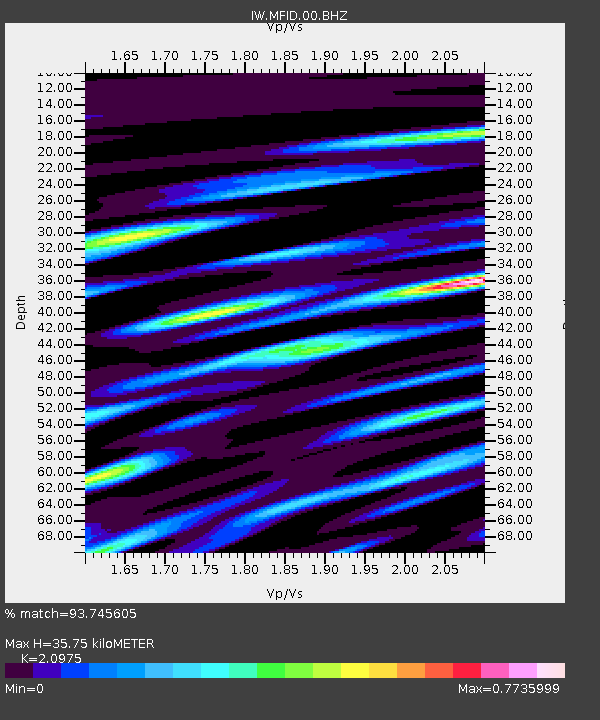
| Estimated Moho Depth: |
35.75 km |
| Estimated Crust Vp/Vs: |
2.10 |
| Assumed Crust Vp: |
6.291 km/s |
| Estimated Crust Vs: |
2.999 km/s |
| Estimated Crust Poisson's Ratio: |
0.35 |
|
| Radial Match: |
93.745605 % |
| Radial Bump: |
400 |
| Transverse Match: |
88.13159 % |
| Transverse Bump: |
400 |
| SOD ConfigId: |
2825771 |
| Insert Time: |
2018-09-23 19:46:03.044 +0000 |
| GWidth: |
2.5 |
| Max Bumps: |
400 |
| Tol: |
0.001 |
|

Signal To Noise
| Channel | StoN | STA | LTA |
| IW:MFID:00:BHZ:20180909T19:44:05.450012Z | 12.91839 | 1.0897855E-6 | 8.4359236E-8 |
| IW:MFID:00:BH1:20180909T19:44:05.450012Z | 4.020346 | 2.2625305E-7 | 5.6277006E-8 |
| IW:MFID:00:BH2:20180909T19:44:05.450012Z | 5.033919 | 3.429237E-7 | 6.812262E-8 |
| Arrivals |
| Ps | 6.3 SECOND |
| PpPs | 17 SECOND |
| PsPs/PpSs | 24 SECOND |


