You are here: Home > Network List > AU - Australian Seismological Centre Stations List
> Station KIM08 GSWA station > Earthquake Result Viewer
KIM08 GSWA station - Earthquake Result Viewer
| Earthquake location: |
Myanmar-India Border Region |
| Earthquake latitude/longitude: |
23.1/94.9 |
| Earthquake time(UTC): |
2022/09/29 (272) 22:22:38 GMT |
| Earthquake Depth: |
165 km |
| Earthquake Magnitude: |
5.6 mww |
| Earthquake Catalog/Contributor: |
NEIC PDE/us |
|
| Network: |
AU Australian Seismological Centre |
| Station: |
KIM08 GSWA station |
| Lat/Lon: |
17.32 S/124.81 E |
| Elevation: |
120 m |
|
| Distance: |
49.6 deg |
| Az: |
141.355 deg |
| Baz: |
322.976 deg |
| Ray Param: |
0.0679854 |
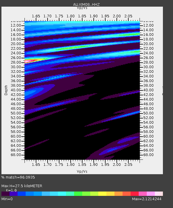
| Estimated Moho Depth: |
27.5 km |
| Estimated Crust Vp/Vs: |
1.60 |
| Assumed Crust Vp: |
6.496 km/s |
| Estimated Crust Vs: |
4.06 km/s |
| Estimated Crust Poisson's Ratio: |
0.18 |
|
| Radial Match: |
96.0935 % |
| Radial Bump: |
230 |
| Transverse Match: |
81.89145 % |
| Transverse Bump: |
400 |
| SOD ConfigId: |
28764291 |
| Insert Time: |
2022-10-13 22:27:41.359 +0000 |
| GWidth: |
2.5 |
| Max Bumps: |
400 |
| Tol: |
0.001 |
|

Signal To Noise
| Channel | StoN | STA | LTA |
| AU:KIM08: :HHZ:20220929T22:30:42.234997Z | 5.118122 | 1.4623371E-6 | 2.857175E-7 |
| AU:KIM08: :HHN:20220929T22:30:42.234997Z | 4.937579 | 1.6642633E-6 | 3.3706058E-7 |
| AU:KIM08: :HHE:20220929T22:30:42.234997Z | 4.6401887 | 1.0056358E-6 | 2.1672305E-7 |
| Arrivals |
| Ps | 2.7 SECOND |
| PpPs | 10 SECOND |
| PsPs/PpSs | 13 SECOND |


