You are here: Home > Network List > XA95 - Missouri to Massachusetts Transect Stations List
> Station MM04 LeRaysville, Pennsylvania > Earthquake Result Viewer
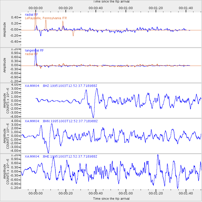
MM04 LeRaysville, Pennsylvania - Earthquake Result Viewer
*The percent match for this event was below the threshold and hence no stack was calculated.
| Earthquake location: |
Peru-Ecuador Border Region |
| Earthquake latitude/longitude: |
-2.8/-77.9 |
| Earthquake time(UTC): |
1995/10/03 (276) 12:45:00 GMT |
| Earthquake Depth: |
33 km |
| Earthquake Magnitude: |
6.0 MB, 6.1 MS, 5.9 UNKNOWN, 6.4 MW |
| Earthquake Catalog/Contributor: |
WHDF/NEIC |
|
| Network: |
XA Missouri to Massachusetts Transect |
| Station: |
MM04 LeRaysville, Pennsylvania |
| Lat/Lon: |
41.85 N/76.20 W |
| Elevation: |
473 m |
|
| Distance: |
44.5 deg |
| Az: |
1.811 deg |
| Baz: |
182.422 deg |
| Ray Param: |
$rayparam |
*The percent match for this event was below the threshold and hence was not used in the summary stack. |
|
| Radial Match: |
68.42676 % |
| Radial Bump: |
400 |
| Transverse Match: |
98.202736 % |
| Transverse Bump: |
167 |
| SOD ConfigId: |
4480 |
| Insert Time: |
2010-02-26 17:45:33.672 +0000 |
| GWidth: |
2.5 |
| Max Bumps: |
400 |
| Tol: |
0.001 |
|
Signal To Noise
| Channel | StoN | STA | LTA |
| XA:MM04: :BHN:19951003T12:52:37.718988Z | 5.0904727 | 1.2561733E-6 | 2.4676947E-7 |
| XA:MM04: :BHE:19951003T12:52:37.718988Z | 1.8678349 | 4.862513E-7 | 2.6032885E-7 |
| XA:MM04: :BHZ:19951003T12:52:37.718988Z | 4.964671 | 1.251022E-6 | 2.519849E-7 |
| Arrivals |
| Ps | |
| PpPs | |
| PsPs/PpSs | |


