You are here: Home > Network List > AV - Alaska Volcano Observatory Stations List
> Station SPNN North Nagishlamina, Mount Spurr, Alaska > Earthquake Result Viewer
SPNN North Nagishlamina, Mount Spurr, Alaska - Earthquake Result Viewer
| Earthquake location: |
Reykjanes Ridge |
| Earthquake latitude/longitude: |
53.7/-35.5 |
| Earthquake time(UTC): |
2022/10/01 (274) 01:18:53 GMT |
| Earthquake Depth: |
10 km |
| Earthquake Magnitude: |
6.0 mww |
| Earthquake Catalog/Contributor: |
NEIC PDE/us |
|
| Network: |
AV Alaska Volcano Observatory |
| Station: |
SPNN North Nagishlamina, Mount Spurr, Alaska |
| Lat/Lon: |
61.37 N/152.70 W |
| Elevation: |
1666 m |
|
| Distance: |
55.0 deg |
| Az: |
328.447 deg |
| Baz: |
40.224 deg |
| Ray Param: |
0.06510572 |
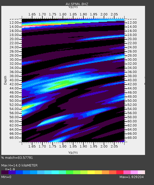
| Estimated Moho Depth: |
14.0 km |
| Estimated Crust Vp/Vs: |
1.60 |
| Assumed Crust Vp: |
6.566 km/s |
| Estimated Crust Vs: |
4.104 km/s |
| Estimated Crust Poisson's Ratio: |
0.18 |
|
| Radial Match: |
83.57791 % |
| Radial Bump: |
293 |
| Transverse Match: |
76.785805 % |
| Transverse Bump: |
350 |
| SOD ConfigId: |
28764291 |
| Insert Time: |
2022-10-15 01:26:34.380 +0000 |
| GWidth: |
2.5 |
| Max Bumps: |
400 |
| Tol: |
0.001 |
|

Signal To Noise
| Channel | StoN | STA | LTA |
| AV:SPNN: :BHZ:20221001T01:27:53.540017Z | 2.7180963 | 3.4549953E-7 | 1.2711085E-7 |
| AV:SPNN: :BHN:20221001T01:27:53.540017Z | 1.7063668 | 2.2285631E-7 | 1.3060283E-7 |
| AV:SPNN: :BHE:20221001T01:27:53.540017Z | 1.1276665 | 1.6310788E-7 | 1.4464194E-7 |
| Arrivals |
| Ps | 1.4 SECOND |
| PpPs | 5.2 SECOND |
| PsPs/PpSs | 6.6 SECOND |


