You are here: Home > Network List > G - GEOSCOPE Stations List
> Station MPG Montagne des Peres, French Guyana > Earthquake Result Viewer
MPG Montagne des Peres, French Guyana - Earthquake Result Viewer

| Earthquake location: |
Reykjanes Ridge |
| Earthquake latitude/longitude: |
53.7/-35.5 |
| Earthquake time(UTC): |
2022/10/01 (274) 01:18:53 GMT |
| Earthquake Depth: |
10 km |
| Earthquake Magnitude: |
6.0 mww |
| Earthquake Catalog/Contributor: |
NEIC PDE/us |
|
| Network: |
G GEOSCOPE |
| Station: |
MPG Montagne des Peres, French Guyana |
| Lat/Lon: |
5.11 N/52.64 W |
| Elevation: |
147 m |
|
| Distance: |
50.4 deg |
| Az: |
202.354 deg |
| Baz: |
13.119 deg |
| Ray Param: |
0.06806363 |
| Estimated Moho Depth: |
11.5 km |
| Estimated Crust Vp/Vs: |
1.72 |
| Assumed Crust Vp: |
6.472 km/s |
| Estimated Crust Vs: |
3.763 km/s |
| Estimated Crust Poisson's Ratio: |
0.24 |
|
| Radial Match: |
92.03443 % |
| Radial Bump: |
329 |
| Transverse Match: |
73.97555 % |
| Transverse Bump: |
400 |
| SOD ConfigId: |
28764291 |
| Insert Time: |
2022-10-15 01:32:58.140 +0000 |
| GWidth: |
2.5 |
| Max Bumps: |
400 |
| Tol: |
0.001 |
|
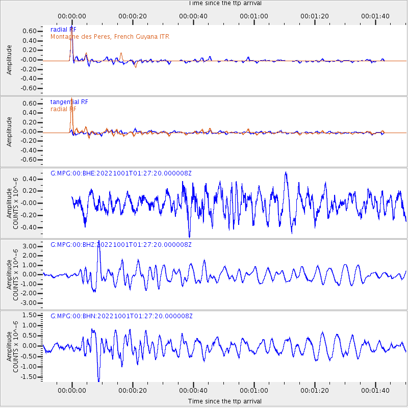
Signal To Noise
| Channel | StoN | STA | LTA |
| G:MPG:00:BHZ:20221001T01:27:20.000008Z | 2.6942844 | 3.7176127E-7 | 1.3798144E-7 |
| G:MPG:00:BHN:20221001T01:27:20.000008Z | 1.554284 | 1.9638286E-7 | 1.263494E-7 |
| G:MPG:00:BHE:20221001T01:27:20.000008Z | 1.064998 | 1.205383E-7 | 1.1318172E-7 |
| Arrivals |
| Ps | 1.4 SECOND |
| PpPs | 4.5 SECOND |
| PsPs/PpSs | 5.9 SECOND |


