You are here: Home > Network List > GO - National Seismic Network of Georgia Stations List
> Station MTAG MTAG,Georgia > Earthquake Result Viewer
MTAG MTAG,Georgia - Earthquake Result Viewer
| Earthquake location: |
Reykjanes Ridge |
| Earthquake latitude/longitude: |
53.7/-35.5 |
| Earthquake time(UTC): |
2022/10/01 (274) 01:18:53 GMT |
| Earthquake Depth: |
10 km |
| Earthquake Magnitude: |
6.0 mww |
| Earthquake Catalog/Contributor: |
NEIC PDE/us |
|
| Network: |
GO National Seismic Network of Georgia |
| Station: |
MTAG MTAG,Georgia |
| Lat/Lon: |
42.09 N/45.16 E |
| Elevation: |
728 m |
|
| Distance: |
52.5 deg |
| Az: |
67.771 deg |
| Baz: |
312.328 deg |
| Ray Param: |
0.066705294 |
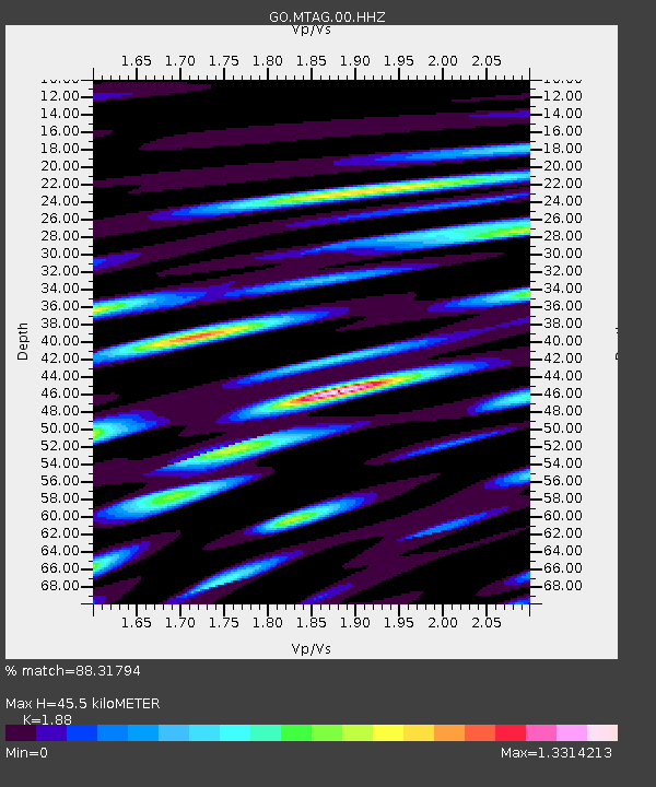
| Estimated Moho Depth: |
45.5 km |
| Estimated Crust Vp/Vs: |
1.88 |
| Assumed Crust Vp: |
6.142 km/s |
| Estimated Crust Vs: |
3.267 km/s |
| Estimated Crust Poisson's Ratio: |
0.30 |
|
| Radial Match: |
88.31794 % |
| Radial Bump: |
400 |
| Transverse Match: |
81.74494 % |
| Transverse Bump: |
400 |
| SOD ConfigId: |
28764291 |
| Insert Time: |
2022-10-15 01:33:41.153 +0000 |
| GWidth: |
2.5 |
| Max Bumps: |
400 |
| Tol: |
0.001 |
|

Signal To Noise
| Channel | StoN | STA | LTA |
| GO:MTAG:00:HHZ:20221001T01:27:35.530007Z | 5.8782053 | 2.4984388E-7 | 4.250343E-8 |
| GO:MTAG:00:HHN:20221001T01:27:35.530007Z | 1.404135 | 9.8080356E-8 | 6.985109E-8 |
| GO:MTAG:00:HHE:20221001T01:27:35.530007Z | 1.797809 | 6.108381E-8 | 3.3976807E-8 |
| Arrivals |
| Ps | 6.8 SECOND |
| PpPs | 20 SECOND |
| PsPs/PpSs | 27 SECOND |


