You are here: Home > Network List > UW - Pacific Northwest Regional Seismic Network Stations List
> Station LEBA Lebam, WA, USA > Earthquake Result Viewer
LEBA Lebam, WA, USA - Earthquake Result Viewer
| Earthquake location: |
Reykjanes Ridge |
| Earthquake latitude/longitude: |
53.7/-35.5 |
| Earthquake time(UTC): |
2022/10/01 (274) 01:18:53 GMT |
| Earthquake Depth: |
10 km |
| Earthquake Magnitude: |
6.0 mww |
| Earthquake Catalog/Contributor: |
NEIC PDE/us |
|
| Network: |
UW Pacific Northwest Regional Seismic Network |
| Station: |
LEBA Lebam, WA, USA |
| Lat/Lon: |
46.55 N/123.56 W |
| Elevation: |
73 m |
|
| Distance: |
53.4 deg |
| Az: |
300.795 deg |
| Baz: |
47.716 deg |
| Ray Param: |
0.066125706 |
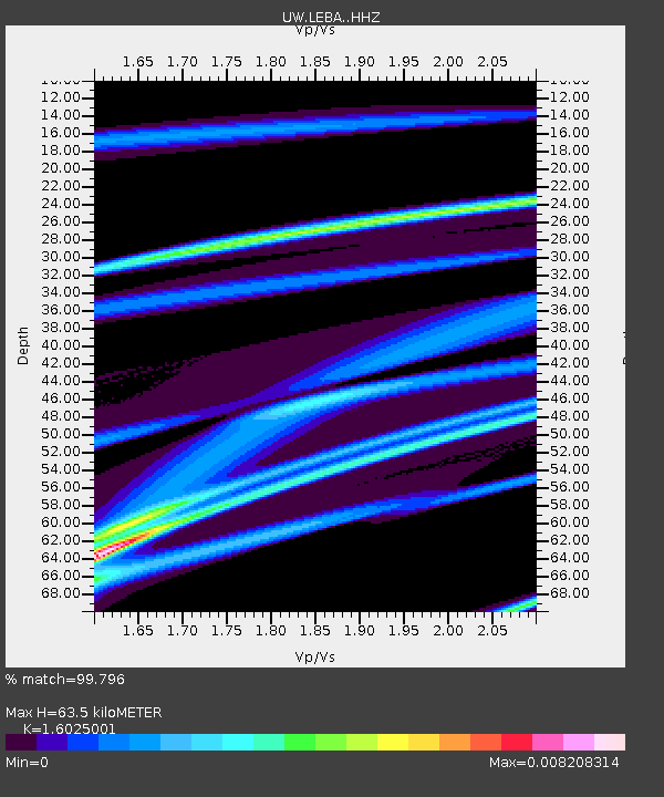
| Estimated Moho Depth: |
63.5 km |
| Estimated Crust Vp/Vs: |
1.60 |
| Assumed Crust Vp: |
6.566 km/s |
| Estimated Crust Vs: |
4.097 km/s |
| Estimated Crust Poisson's Ratio: |
0.18 |
|
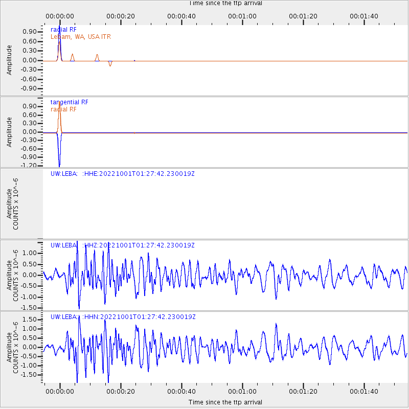
| Radial Match: |
99.796 % |
| Radial Bump: |
20 |
| Transverse Match: |
99.796 % |
| Transverse Bump: |
20 |
| SOD ConfigId: |
28764291 |
| Insert Time: |
2022-10-15 01:48:22.212 +0000 |
| GWidth: |
2.5 |
| Max Bumps: |
400 |
| Tol: |
0.001 |
|
Signal To Noise
| Channel | StoN | STA | LTA |
| UW:LEBA: :HHZ:20221001T01:27:42.230019Z | 2.5146697 | 3.1916412E-7 | 1.2692088E-7 |
| UW:LEBA: :HHN:20221001T01:27:42.230019Z | 2.4932804 | 3.7241878E-7 | 1.4936899E-7 |
| $trig.getChannelId() | $trig.getValue() | $trig.getSTA() | $trig.getLTA() |
| Arrivals |
| Ps | 6.2 SECOND |
| PpPs | 24 SECOND |
| PsPs/PpSs | 30 SECOND |


