You are here: Home > Network List > WW - Idaho Seismic Network () Stations List
> Station BILL Emerald Creek, Idaho > Earthquake Result Viewer
BILL Emerald Creek, Idaho - Earthquake Result Viewer
| Earthquake location: |
Reykjanes Ridge |
| Earthquake latitude/longitude: |
53.7/-35.5 |
| Earthquake time(UTC): |
2022/10/01 (274) 01:18:53 GMT |
| Earthquake Depth: |
10 km |
| Earthquake Magnitude: |
6.0 mww |
| Earthquake Catalog/Contributor: |
NEIC PDE/us |
|
| Network: |
WW Idaho Seismic Network () |
| Station: |
BILL Emerald Creek, Idaho |
| Lat/Lon: |
47.03 N/116.34 W |
| Elevation: |
866 m |
|
| Distance: |
49.3 deg |
| Az: |
297.116 deg |
| Baz: |
50.67 deg |
| Ray Param: |
0.068774976 |
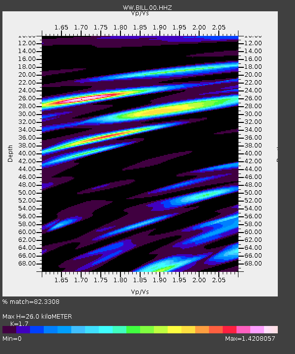
| Estimated Moho Depth: |
26.0 km |
| Estimated Crust Vp/Vs: |
1.70 |
| Assumed Crust Vp: |
6.571 km/s |
| Estimated Crust Vs: |
3.865 km/s |
| Estimated Crust Poisson's Ratio: |
0.24 |
|
| Radial Match: |
82.3308 % |
| Radial Bump: |
400 |
| Transverse Match: |
47.31149 % |
| Transverse Bump: |
400 |
| SOD ConfigId: |
28764291 |
| Insert Time: |
2022-10-15 01:51:44.374 +0000 |
| GWidth: |
2.5 |
| Max Bumps: |
400 |
| Tol: |
0.001 |
|
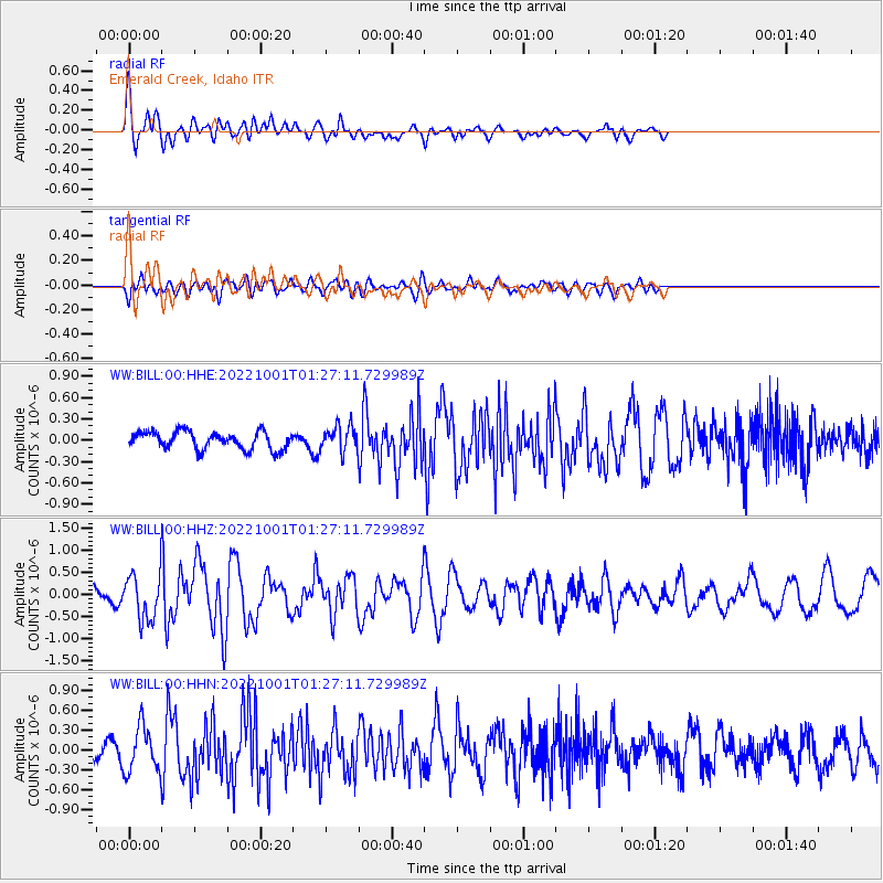
Signal To Noise
| Channel | StoN | STA | LTA |
| WW:BILL:00:HHZ:20221001T01:27:11.729989Z | 2.91618 | 4.965056E-7 | 1.7025891E-7 |
| WW:BILL:00:HHN:20221001T01:27:11.729989Z | 2.0982552 | 3.452001E-7 | 1.645177E-7 |
| WW:BILL:00:HHE:20221001T01:27:11.729989Z | 1.4235059 | 1.7661483E-7 | 1.2407031E-7 |
| Arrivals |
| Ps | 3.0 SECOND |
| PpPs | 10 SECOND |
| PsPs/PpSs | 13 SECOND |


