You are here: Home > Network List > AU - Australian Seismological Centre Stations List
> Station PSAA3 Pilbara Seismic Array Element A3 > Earthquake Result Viewer
PSAA3 Pilbara Seismic Array Element A3 - Earthquake Result Viewer
| Earthquake location: |
South Of Kermadec Islands |
| Earthquake latitude/longitude: |
-32.4/-178.5 |
| Earthquake time(UTC): |
2018/09/10 (253) 04:18:59 GMT |
| Earthquake Depth: |
134 km |
| Earthquake Magnitude: |
7.0 Mi |
| Earthquake Catalog/Contributor: |
NEIC PDE/at |
|
| Network: |
AU Australian Seismological Centre |
| Station: |
PSAA3 Pilbara Seismic Array Element A3 |
| Lat/Lon: |
21.58 S/119.85 E |
| Elevation: |
315 m |
|
| Distance: |
55.3 deg |
| Az: |
264.867 deg |
| Baz: |
115.145 deg |
| Ray Param: |
0.06443945 |
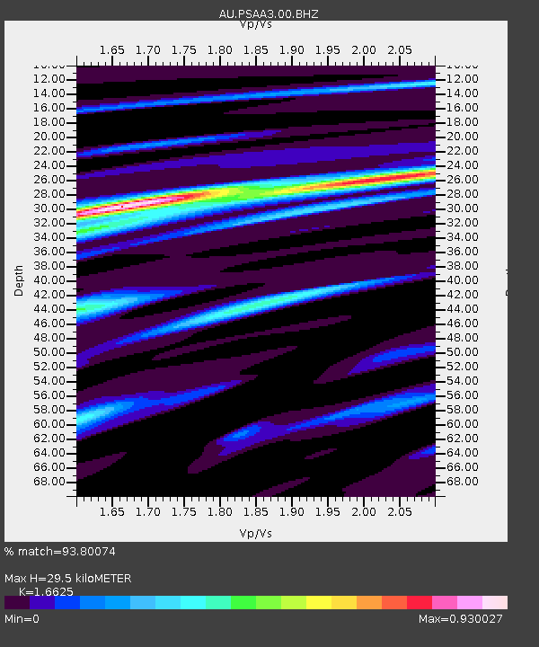
| Estimated Moho Depth: |
29.5 km |
| Estimated Crust Vp/Vs: |
1.66 |
| Assumed Crust Vp: |
6.464 km/s |
| Estimated Crust Vs: |
3.888 km/s |
| Estimated Crust Poisson's Ratio: |
0.22 |
|
| Radial Match: |
93.80074 % |
| Radial Bump: |
366 |
| Transverse Match: |
71.37961 % |
| Transverse Bump: |
400 |
| SOD ConfigId: |
2825771 |
| Insert Time: |
2018-09-24 04:30:48.918 +0000 |
| GWidth: |
2.5 |
| Max Bumps: |
400 |
| Tol: |
0.001 |
|

Signal To Noise
| Channel | StoN | STA | LTA |
| AU:PSAA3:00:BHZ:20180910T04:27:48.143982Z | 14.371624 | 7.3912697E-6 | 5.142961E-7 |
| AU:PSAA3:00:BH1:20180910T04:27:48.143982Z | 7.649745 | 1.432081E-6 | 1.8720638E-7 |
| AU:PSAA3:00:BH2:20180910T04:27:48.143982Z | 15.954799 | 3.3652757E-6 | 2.109256E-7 |
| Arrivals |
| Ps | 3.2 SECOND |
| PpPs | 11 SECOND |
| PsPs/PpSs | 15 SECOND |


