You are here: Home > Network List > XA95 - Missouri to Massachusetts Transect Stations List
> Station MM05 Gleason, Pennsylvania > Earthquake Result Viewer
MM05 Gleason, Pennsylvania - Earthquake Result Viewer
| Earthquake location: |
Off Coast Of Central America |
| Earthquake latitude/longitude: |
12.2/-88.3 |
| Earthquake time(UTC): |
1995/06/14 (165) 11:11:49 GMT |
| Earthquake Depth: |
39 km |
| Earthquake Magnitude: |
5.6 MB, 6.0 MS, 6.6 UNKNOWN |
| Earthquake Catalog/Contributor: |
WHDF/NEIC |
|
| Network: |
XA Missouri to Massachusetts Transect |
| Station: |
MM05 Gleason, Pennsylvania |
| Lat/Lon: |
41.65 N/76.92 W |
| Elevation: |
701 m |
|
| Distance: |
31.0 deg |
| Az: |
16.758 deg |
| Baz: |
202.096 deg |
| Ray Param: |
0.07914452 |
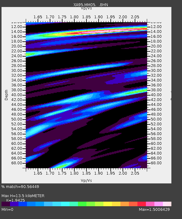
| Estimated Moho Depth: |
13.5 km |
| Estimated Crust Vp/Vs: |
1.94 |
| Assumed Crust Vp: |
6.121 km/s |
| Estimated Crust Vs: |
3.151 km/s |
| Estimated Crust Poisson's Ratio: |
0.32 |
|
| Radial Match: |
90.56449 % |
| Radial Bump: |
369 |
| Transverse Match: |
72.70421 % |
| Transverse Bump: |
400 |
| SOD ConfigId: |
29242 |
| Insert Time: |
2010-02-26 17:45:42.749 +0000 |
| GWidth: |
2.5 |
| Max Bumps: |
400 |
| Tol: |
0.001 |
|
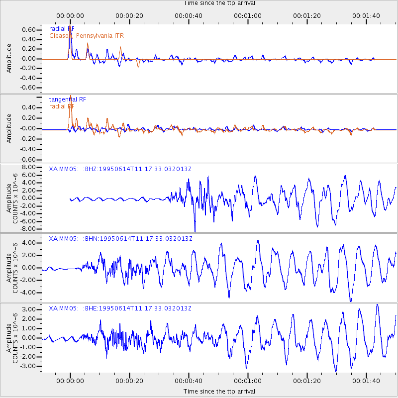
Signal To Noise
| Channel | StoN | STA | LTA |
| XA:MM05: :BHN:19950614T11:17:33.032013Z | 1.1220225 | 2.1283977E-7 | 1.8969294E-7 |
| XA:MM05: :BHE:19950614T11:17:33.032013Z | 1.2981886 | 2.1759175E-7 | 1.6761182E-7 |
| XA:MM05: :BHZ:19950614T11:17:33.032013Z | 1.5777782 | 4.323053E-7 | 2.7399625E-7 |
| Arrivals |
| Ps | 2.2 SECOND |
| PpPs | 6.1 SECOND |
| PsPs/PpSs | 8.3 SECOND |


