You are here: Home > Network List > IW - Intermountain West Stations List
> Station MOOW Moose Ponds, Wyoming, USA > Earthquake Result Viewer
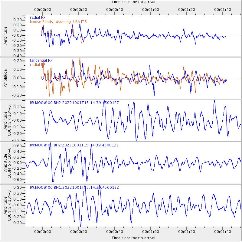
MOOW Moose Ponds, Wyoming, USA - Earthquake Result Viewer
*The percent match for this event was below the threshold and hence no stack was calculated.
| Earthquake location: |
Kyushu, Japan |
| Earthquake latitude/longitude: |
31.3/131.5 |
| Earthquake time(UTC): |
2022/10/01 (274) 15:02:32 GMT |
| Earthquake Depth: |
28 km |
| Earthquake Magnitude: |
5.7 mww |
| Earthquake Catalog/Contributor: |
NEIC PDE/us |
|
| Network: |
IW Intermountain West |
| Station: |
MOOW Moose Ponds, Wyoming, USA |
| Lat/Lon: |
43.75 N/110.74 W |
| Elevation: |
2128 m |
|
| Distance: |
86.1 deg |
| Az: |
39.98 deg |
| Baz: |
310.645 deg |
| Ray Param: |
$rayparam |
*The percent match for this event was below the threshold and hence was not used in the summary stack. |
|
| Radial Match: |
68.97381 % |
| Radial Bump: |
400 |
| Transverse Match: |
70.984474 % |
| Transverse Bump: |
381 |
| SOD ConfigId: |
28764291 |
| Insert Time: |
2022-10-15 15:20:05.955 +0000 |
| GWidth: |
2.5 |
| Max Bumps: |
400 |
| Tol: |
0.001 |
|
Signal To Noise
| Channel | StoN | STA | LTA |
| IW:MOOW:00:BHZ:20221001T15:14:39.450012Z | 3.4584236 | 2.8932124E-7 | 8.3656964E-8 |
| IW:MOOW:00:BH1:20221001T15:14:39.450012Z | 1.0842447 | 7.750631E-8 | 7.148415E-8 |
| IW:MOOW:00:BH2:20221001T15:14:39.450012Z | 1.8506391 | 1.418089E-7 | 7.662699E-8 |
| Arrivals |
| Ps | |
| PpPs | |
| PsPs/PpSs | |


