You are here: Home > Network List > KR - Kyrgyz Digital Network Stations List
> Station SALK Salom-Alik, Kyrgyzstan > Earthquake Result Viewer
SALK Salom-Alik, Kyrgyzstan - Earthquake Result Viewer
| Earthquake location: |
Kyushu, Japan |
| Earthquake latitude/longitude: |
31.3/131.5 |
| Earthquake time(UTC): |
2022/10/01 (274) 15:02:32 GMT |
| Earthquake Depth: |
28 km |
| Earthquake Magnitude: |
5.7 mww |
| Earthquake Catalog/Contributor: |
NEIC PDE/us |
|
| Network: |
KR Kyrgyz Digital Network |
| Station: |
SALK Salom-Alik, Kyrgyzstan |
| Lat/Lon: |
40.88 N/73.82 E |
| Elevation: |
1672 m |
|
| Distance: |
46.8 deg |
| Az: |
298.521 deg |
| Baz: |
82.628 deg |
| Ray Param: |
0.07037287 |
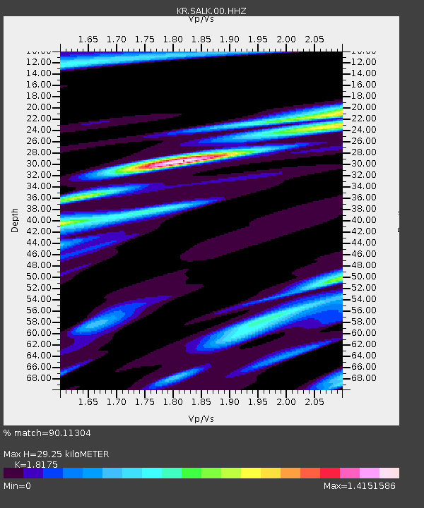
| Estimated Moho Depth: |
29.25 km |
| Estimated Crust Vp/Vs: |
1.82 |
| Assumed Crust Vp: |
6.306 km/s |
| Estimated Crust Vs: |
3.47 km/s |
| Estimated Crust Poisson's Ratio: |
0.28 |
|
| Radial Match: |
90.11304 % |
| Radial Bump: |
400 |
| Transverse Match: |
72.96994 % |
| Transverse Bump: |
400 |
| SOD ConfigId: |
28764291 |
| Insert Time: |
2022-10-15 15:20:43.212 +0000 |
| GWidth: |
2.5 |
| Max Bumps: |
400 |
| Tol: |
0.001 |
|

Signal To Noise
| Channel | StoN | STA | LTA |
| KR:SALK:00:HHZ:20221001T15:10:28.730011Z | 10.518294 | 7.3102376E-7 | 6.950022E-8 |
| KR:SALK:00:HHN:20221001T15:10:28.730011Z | 2.3784559 | 1.1324935E-7 | 4.7614652E-8 |
| KR:SALK:00:HHE:20221001T15:10:28.730011Z | 10.560597 | 4.013321E-7 | 3.8002785E-8 |
| Arrivals |
| Ps | 4.0 SECOND |
| PpPs | 12 SECOND |
| PsPs/PpSs | 16 SECOND |


