You are here: Home > Network List > IU - Global Seismograph Network (GSN - IRIS/USGS) Stations List
> Station NWAO Narrogin, Australia > Earthquake Result Viewer
NWAO Narrogin, Australia - Earthquake Result Viewer
| Earthquake location: |
South Of Kermadec Islands |
| Earthquake latitude/longitude: |
-32.4/-178.5 |
| Earthquake time(UTC): |
2018/09/10 (253) 04:18:59 GMT |
| Earthquake Depth: |
134 km |
| Earthquake Magnitude: |
7.0 Mi |
| Earthquake Catalog/Contributor: |
NEIC PDE/at |
|
| Network: |
IU Global Seismograph Network (GSN - IRIS/USGS) |
| Station: |
NWAO Narrogin, Australia |
| Lat/Lon: |
32.93 S/117.24 E |
| Elevation: |
380 m |
|
| Distance: |
53.3 deg |
| Az: |
250.862 deg |
| Baz: |
108.145 deg |
| Ray Param: |
0.065732434 |
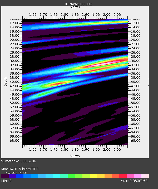
| Estimated Moho Depth: |
31.5 km |
| Estimated Crust Vp/Vs: |
1.97 |
| Assumed Crust Vp: |
6.419 km/s |
| Estimated Crust Vs: |
3.254 km/s |
| Estimated Crust Poisson's Ratio: |
0.33 |
|
| Radial Match: |
93.806786 % |
| Radial Bump: |
296 |
| Transverse Match: |
77.436775 % |
| Transverse Bump: |
400 |
| SOD ConfigId: |
2825771 |
| Insert Time: |
2018-09-24 04:32:14.268 +0000 |
| GWidth: |
2.5 |
| Max Bumps: |
400 |
| Tol: |
0.001 |
|

Signal To Noise
| Channel | StoN | STA | LTA |
| IU:NWAO:00:BHZ:20180910T04:27:33.619019Z | 6.135641 | 4.977903E-6 | 8.113093E-7 |
| IU:NWAO:00:BH1:20180910T04:27:33.619019Z | 2.407845 | 2.325818E-6 | 9.659334E-7 |
| IU:NWAO:00:BH2:20180910T04:27:33.619019Z | 3.7913926 | 1.5098332E-6 | 3.9822655E-7 |
| Arrivals |
| Ps | 5.0 SECOND |
| PpPs | 14 SECOND |
| PsPs/PpSs | 19 SECOND |


