You are here: Home > Network List > XA95 - Missouri to Massachusetts Transect Stations List
> Station MM05 Gleason, Pennsylvania > Earthquake Result Viewer
MM05 Gleason, Pennsylvania - Earthquake Result Viewer
| Earthquake location: |
Colombia |
| Earthquake latitude/longitude: |
5.1/-75.7 |
| Earthquake time(UTC): |
1995/08/19 (231) 21:43:32 GMT |
| Earthquake Depth: |
125 km |
| Earthquake Magnitude: |
6.1 MB, 6.6 UNKNOWN, 6.5 MW |
| Earthquake Catalog/Contributor: |
WHDF/NEIC |
|
| Network: |
XA Missouri to Massachusetts Transect |
| Station: |
MM05 Gleason, Pennsylvania |
| Lat/Lon: |
41.65 N/76.92 W |
| Elevation: |
701 m |
|
| Distance: |
36.4 deg |
| Az: |
358.445 deg |
| Baz: |
177.933 deg |
| Ray Param: |
0.07627139 |
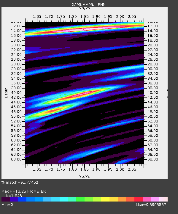
| Estimated Moho Depth: |
13.25 km |
| Estimated Crust Vp/Vs: |
1.85 |
| Assumed Crust Vp: |
6.121 km/s |
| Estimated Crust Vs: |
3.317 km/s |
| Estimated Crust Poisson's Ratio: |
0.29 |
|
| Radial Match: |
91.77452 % |
| Radial Bump: |
400 |
| Transverse Match: |
72.51054 % |
| Transverse Bump: |
400 |
| SOD ConfigId: |
6273 |
| Insert Time: |
2010-02-26 17:45:48.606 +0000 |
| GWidth: |
2.5 |
| Max Bumps: |
400 |
| Tol: |
0.001 |
|
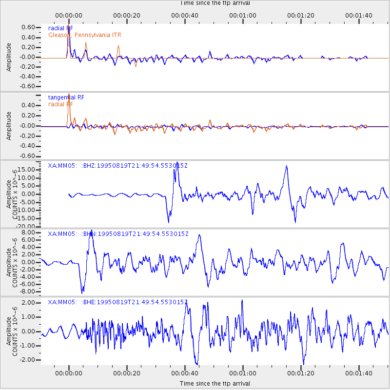
Signal To Noise
| Channel | StoN | STA | LTA |
| XA:MM05: :BHN:19950819T21:49:54.553015Z | 7.726701 | 2.8693412E-6 | 3.71354E-7 |
| XA:MM05: :BHE:19950819T21:49:54.553015Z | 0.80931103 | 3.2935597E-7 | 4.0695846E-7 |
| XA:MM05: :BHZ:19950819T21:49:54.553015Z | 9.234821 | 5.8547384E-6 | 6.3398505E-7 |
| Arrivals |
| Ps | 1.9 SECOND |
| PpPs | 5.8 SECOND |
| PsPs/PpSs | 7.7 SECOND |


