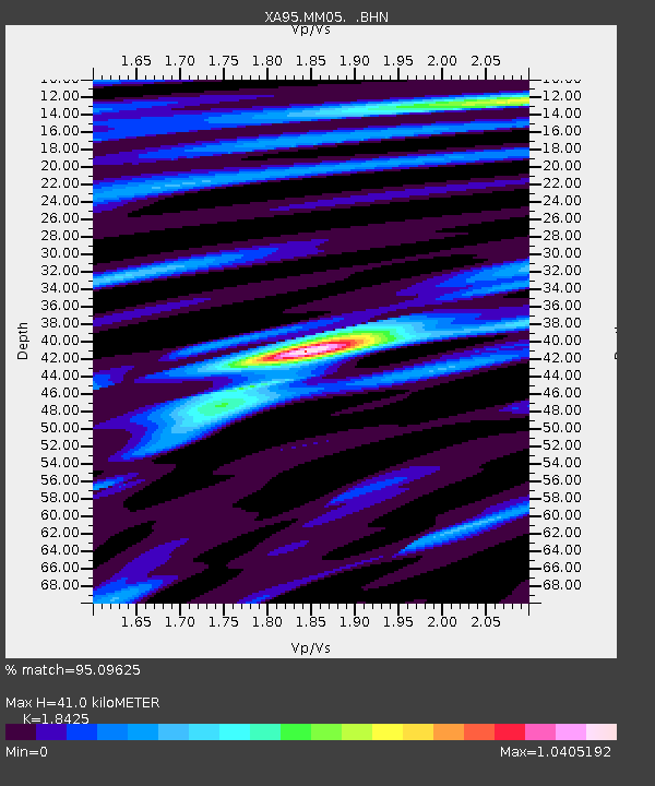
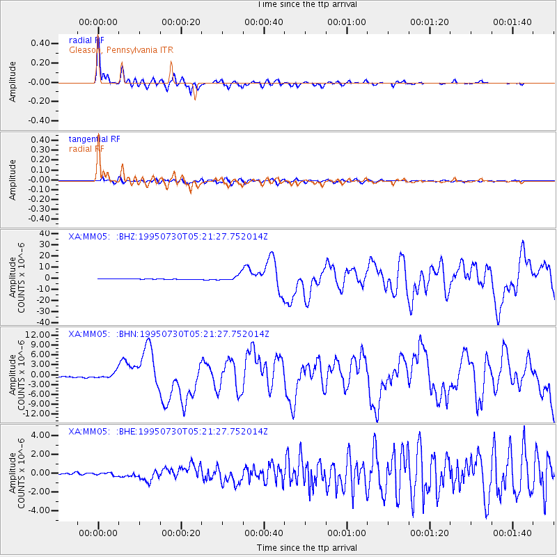
MM05 Gleason, Pennsylvania - Earthquake Result Viewer

Earthquake location: Near Coast Of Northern Chile
Earthquake latitude/longitude: -23.4/-70.3
Earthquake time(UTC): 1995/07/30 (211) 05:11:23 GMT
Earthquake Depth: 47 km
Earthquake Magnitude: 6.6 MB, 7.3 MS, 7.2 UNKNOWN, 8.1 MW
Earthquake Catalog/Contributor: WHDF/NEIC
Network: XA Missouri to Massachusetts Transect
Station: MM05 Gleason, Pennsylvania
Lat/Lon: 41.65 N/76.92 W
Elevation: 701 m
Distance: 65.0 deg
Az: 354.537 deg
Baz: 173.296 deg
Ray Param: 0.05847883
Estimated Moho Depth: 41.0 km
Estimated Crust Vp/Vs: 1.84
Assumed Crust Vp: 6.121 km/s
Estimated Crust Vs: 3.322 km/s
Estimated Crust Poisson's Ratio: 0.29
Radial Match: 95.09625 %
Radial Bump: 400
Transverse Match: 81.83846 %
Transverse Bump: 400
SOD ConfigId: 6273
Insert Time: 2010-02-26 17:45:51.308 +0000
GWidth: 2.5
Max Bumps: 400
Tol: 0.001

Signal To Noise

ChannelStoNSTALTA
XA:MM05: :BHN:19950730T05:21:27.752014Z4.9715781.003968E-62.0194152E-7
XA:MM05: :BHE:19950730T05:21:27.752014Z1.92474851.6026543E-78.3265654E-8
XA:MM05: :BHZ:19950730T05:21:27.752014Z10.1749633.042541E-62.990223E-7
Arrivals
Ps5.9 SECOND
PpPs18 SECOND
PsPs/PpSs24 SECOND