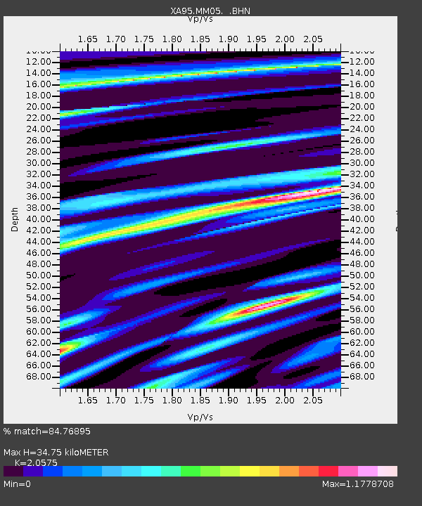
MM05 Gleason, Pennsylvania - Earthquake Result Viewer
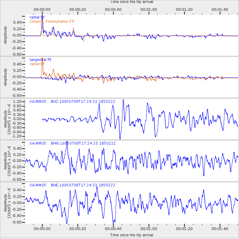
Earthquake location: Unimak Island Region, Alaska
Earthquake latitude/longitude: 53.6/-163.5
Earthquake time(UTC): 1995/07/08 (189) 17:15:28 GMT
Earthquake Depth: 33 km
Earthquake Magnitude: 5.8 MB, 5.7 MS, 5.5 UNKNOWN, 6.0 MW
Earthquake Catalog/Contributor: WHDF/NEIC
Network: XA Missouri to Massachusetts Transect
Station: MM05 Gleason, Pennsylvania
Lat/Lon: 41.65 N/76.92 W
Elevation: 701 m
Distance: 56.1 deg
Az: 64.38 deg
Baz: 314.247 deg
Ray Param: 0.064326406
Estimated Moho Depth: 34.75 km
Estimated Crust Vp/Vs: 2.06
Assumed Crust Vp: 6.121 km/s
Estimated Crust Vs: 2.975 km/s
Estimated Crust Poisson's Ratio: 0.35
Radial Match: 84.76895 %
Radial Bump: 400
Transverse Match: 62.07426 %
Transverse Bump: 400
SOD ConfigId: 6273
Insert Time: 2010-02-26 17:45:52.557 +0000
GWidth: 2.5
Max Bumps: 400
Tol: 0.001

Signal To Noise

ChannelStoNSTALTA
XA:MM05: :BHN:19950708T17:24:33.185022Z2.92880941.858551E-76.345756E-8
XA:MM05: :BHE:19950708T17:24:33.185022Z2.31813981.5346542E-76.620196E-8
XA:MM05: :BHZ:19950708T17:24:33.185022Z6.6165755.238694E-77.917532E-8
Arrivals
Ps6.2 SECOND
PpPs17 SECOND
PsPs/PpSs23 SECOND