You are here: Home > Network List > UW - Pacific Northwest Regional Seismic Network Stations List
> Station DAVN Davenport, WA, USA > Earthquake Result Viewer
DAVN Davenport, WA, USA - Earthquake Result Viewer
| Earthquake location: |
Near Coast Of Oaxaca, Mexico |
| Earthquake latitude/longitude: |
15.0/-94.0 |
| Earthquake time(UTC): |
2022/10/01 (274) 16:36:50 GMT |
| Earthquake Depth: |
24 km |
| Earthquake Magnitude: |
5.5 mww |
| Earthquake Catalog/Contributor: |
NEIC PDE/us |
|
| Network: |
UW Pacific Northwest Regional Seismic Network |
| Station: |
DAVN Davenport, WA, USA |
| Lat/Lon: |
47.80 N/118.27 W |
| Elevation: |
483 m |
|
| Distance: |
38.4 deg |
| Az: |
333.49 deg |
| Baz: |
140.228 deg |
| Ray Param: |
0.075597845 |
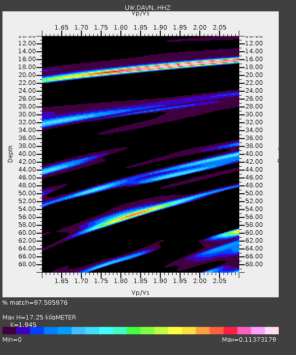
| Estimated Moho Depth: |
17.25 km |
| Estimated Crust Vp/Vs: |
1.95 |
| Assumed Crust Vp: |
6.419 km/s |
| Estimated Crust Vs: |
3.3 km/s |
| Estimated Crust Poisson's Ratio: |
0.32 |
|
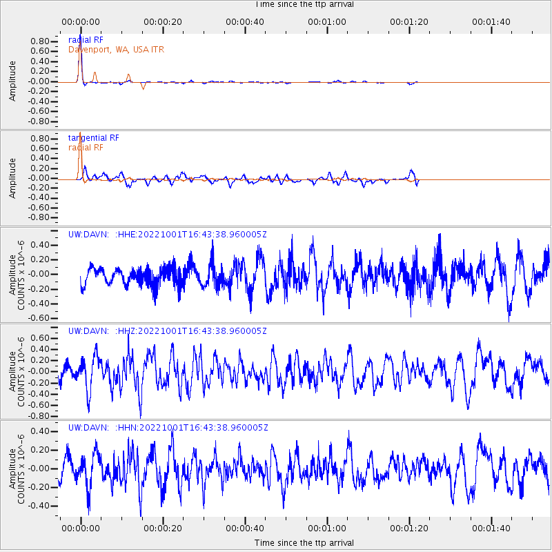
| Radial Match: |
97.585976 % |
| Radial Bump: |
110 |
| Transverse Match: |
54.016552 % |
| Transverse Bump: |
358 |
| SOD ConfigId: |
28764291 |
| Insert Time: |
2022-10-15 16:54:06.221 +0000 |
| GWidth: |
2.5 |
| Max Bumps: |
400 |
| Tol: |
0.001 |
|
Signal To Noise
| Channel | StoN | STA | LTA |
| UW:DAVN: :HHZ:20221001T16:43:38.960005Z | 2.9774234 | 3.0457724E-7 | 1.0229558E-7 |
| UW:DAVN: :HHN:20221001T16:43:38.960005Z | 2.4092264 | 1.8259772E-7 | 7.5791014E-8 |
| UW:DAVN: :HHE:20221001T16:43:38.960005Z | 1.3647258 | 1.5452814E-7 | 1.13230165E-7 |
| Arrivals |
| Ps | 2.7 SECOND |
| PpPs | 7.4 SECOND |
| PsPs/PpSs | 10 SECOND |


