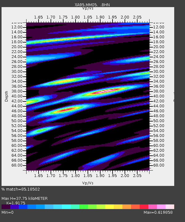
MM05 Gleason, Pennsylvania - Earthquake Result Viewer
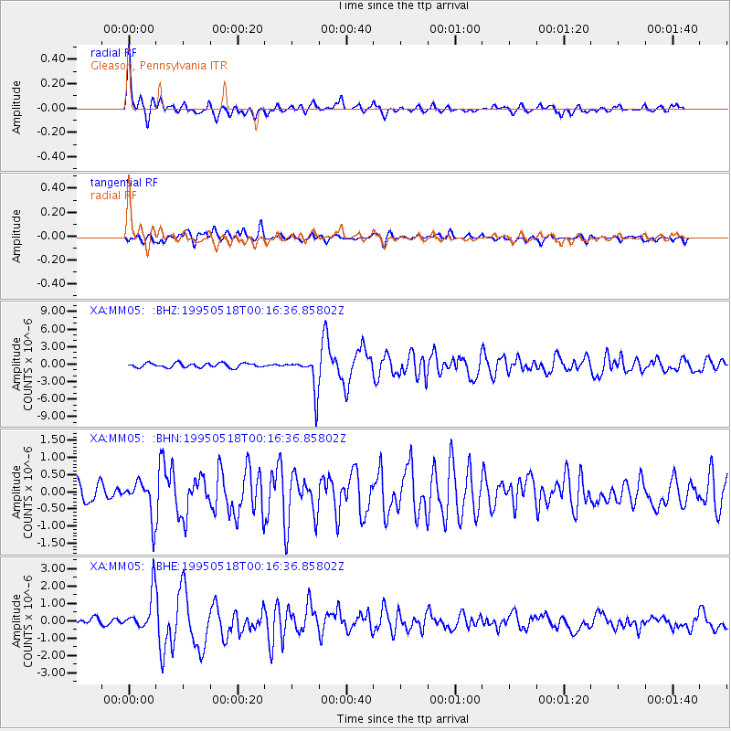
Earthquake location: Central Mid-Atlantic Ridge
Earthquake latitude/longitude: -0.9/-22.0
Earthquake time(UTC): 1995/05/18 (138) 00:06:26 GMT
Earthquake Depth: 10 km
Earthquake Magnitude: 6.2 MB, 6.1 MS, 6.8 UNKNOWN, 6.7 MW
Earthquake Catalog/Contributor: WHDF/NEIC
Network: XA Missouri to Massachusetts Transect
Station: MM05 Gleason, Pennsylvania
Lat/Lon: 41.65 N/76.92 W
Elevation: 701 m
Distance: 65.2 deg
Az: 317.488 deg
Baz: 115.631 deg
Ray Param: 0.05843214
Estimated Moho Depth: 37.75 km
Estimated Crust Vp/Vs: 1.92
Assumed Crust Vp: 6.121 km/s
Estimated Crust Vs: 3.192 km/s
Estimated Crust Poisson's Ratio: 0.31
Radial Match: 85.18502 %
Radial Bump: 400
Transverse Match: 82.60317 %
Transverse Bump: 400
SOD ConfigId: 6273
Insert Time: 2010-02-26 17:45:54.815 +0000
GWidth: 2.5
Max Bumps: 400
Tol: 0.001

Signal To Noise

ChannelStoNSTALTA
XA:MM05: :BHN:19950518T00:16:36.85802Z1.7527495.3860856E-73.0729362E-7
XA:MM05: :BHE:19950518T00:16:36.85802Z3.8936771.1399004E-62.927568E-7
XA:MM05: :BHZ:19950518T00:16:36.85802Z8.2616283.0460467E-63.686981E-7
Arrivals
Ps5.9 SECOND
PpPs17 SECOND
PsPs/PpSs23 SECOND