You are here: Home > Network List > IU - Global Seismograph Network (GSN - IRIS/USGS) Stations List
> Station JOHN Johnston Island, USA > Earthquake Result Viewer
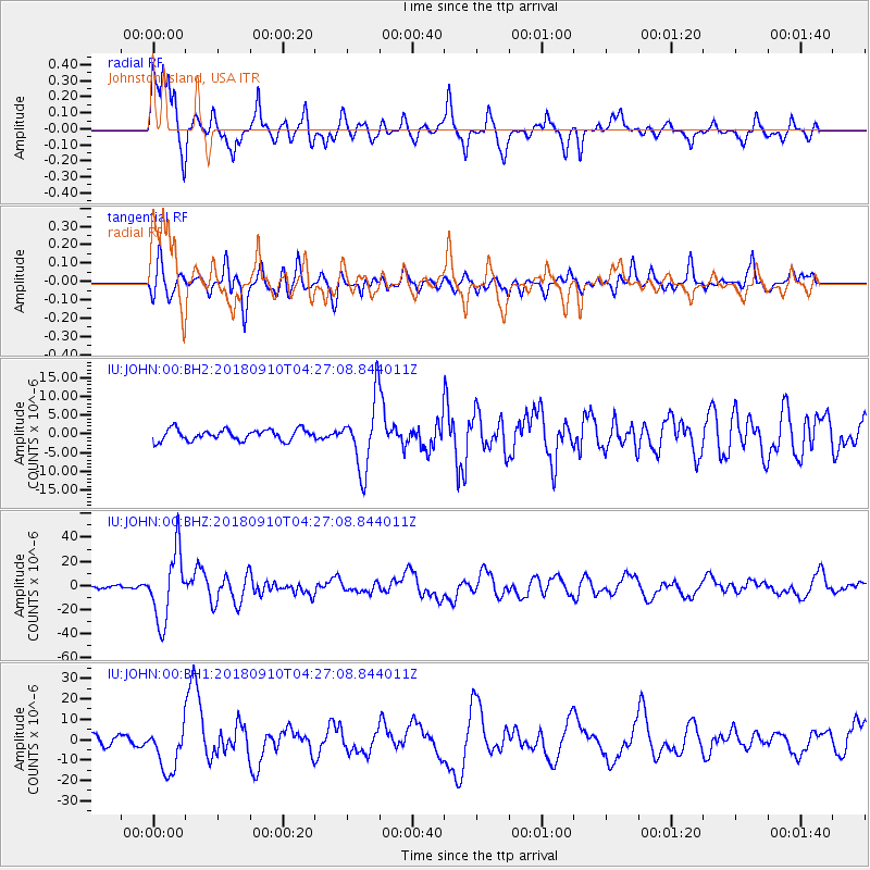
JOHN Johnston Island, USA - Earthquake Result Viewer
*The percent match for this event was below the threshold and hence no stack was calculated.
| Earthquake location: |
Kermadec Islands Region |
| Earthquake latitude/longitude: |
-31.8/-179.3 |
| Earthquake time(UTC): |
2018/09/10 (253) 04:19:02 GMT |
| Earthquake Depth: |
111 km |
| Earthquake Magnitude: |
6.9 mww |
| Earthquake Catalog/Contributor: |
NEIC PDE/us |
|
| Network: |
IU Global Seismograph Network (GSN - IRIS/USGS) |
| Station: |
JOHN Johnston Island, USA |
| Lat/Lon: |
16.73 N/169.53 W |
| Elevation: |
2.0 m |
|
| Distance: |
49.2 deg |
| Az: |
12.446 deg |
| Baz: |
191.037 deg |
| Ray Param: |
$rayparam |
*The percent match for this event was below the threshold and hence was not used in the summary stack. |
|
| Radial Match: |
82.55483 % |
| Radial Bump: |
400 |
| Transverse Match: |
64.13501 % |
| Transverse Bump: |
400 |
| SOD ConfigId: |
2825771 |
| Insert Time: |
2018-09-24 04:35:50.538 +0000 |
| GWidth: |
2.5 |
| Max Bumps: |
400 |
| Tol: |
0.001 |
|
Signal To Noise
| Channel | StoN | STA | LTA |
| IU:JOHN:00:BHZ:20180910T04:27:08.844011Z | 15.108309 | 2.8506814E-5 | 1.8868302E-6 |
| IU:JOHN:00:BH1:20180910T04:27:08.844011Z | 6.0262694 | 1.1276883E-5 | 1.8712876E-6 |
| IU:JOHN:00:BH2:20180910T04:27:08.844011Z | 6.1415954 | 9.173118E-6 | 1.4936052E-6 |
| Arrivals |
| Ps | |
| PpPs | |
| PsPs/PpSs | |


