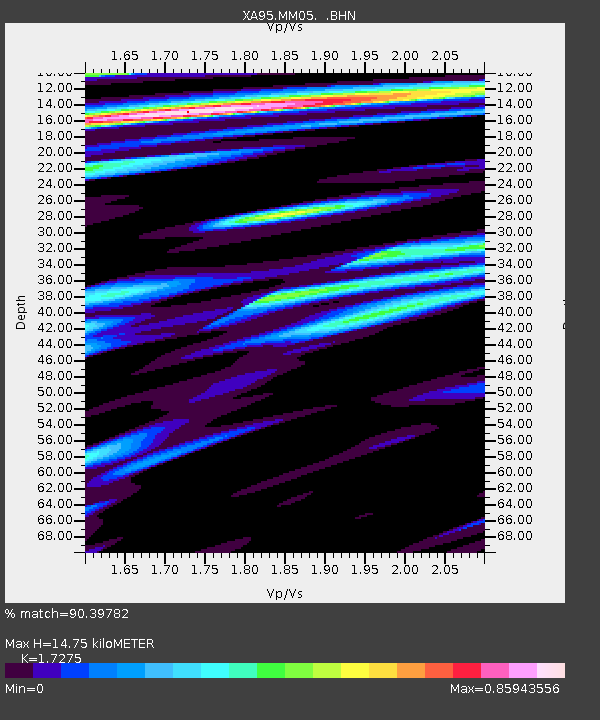
MM05 Gleason, Pennsylvania - Earthquake Result Viewer
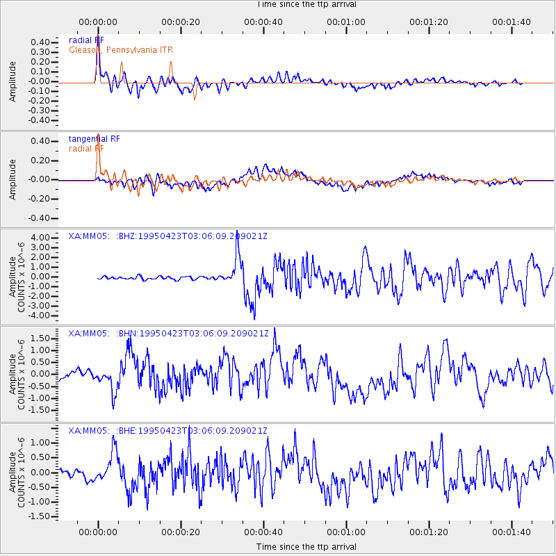
Earthquake location: Rat Islands, Aleutian Islands
Earthquake latitude/longitude: 51.3/179.7
Earthquake time(UTC): 1995/04/23 (113) 02:55:54 GMT
Earthquake Depth: 16 km
Earthquake Magnitude: 6.1 MB, 6.4 MS, 6.5 UNKNOWN, 6.7 ML
Earthquake Catalog/Contributor: WHDF/NEIC
Network: XA Missouri to Massachusetts Transect
Station: MM05 Gleason, Pennsylvania
Lat/Lon: 41.65 N/76.92 W
Elevation: 701 m
Distance: 66.0 deg
Az: 52.959 deg
Baz: 318.079 deg
Ray Param: 0.05790166
Estimated Moho Depth: 14.75 km
Estimated Crust Vp/Vs: 1.73
Assumed Crust Vp: 6.121 km/s
Estimated Crust Vs: 3.543 km/s
Estimated Crust Poisson's Ratio: 0.25
Radial Match: 90.39782 %
Radial Bump: 400
Transverse Match: 55.729862 %
Transverse Bump: 400
SOD ConfigId: 6273
Insert Time: 2010-02-26 17:45:57.511 +0000
GWidth: 2.5
Max Bumps: 400
Tol: 0.001

Signal To Noise

ChannelStoNSTALTA
XA:MM05: :BHN:19950423T03:06:09.209021Z1.59127564.8403314E-73.0417934E-7
XA:MM05: :BHE:19950423T03:06:09.209021Z3.1616685.380939E-71.7019303E-7
XA:MM05: :BHZ:19950423T03:06:09.209021Z10.8089751.6086611E-61.4882642E-7
Arrivals
Ps1.8 SECOND
PpPs6.3 SECOND
PsPs/PpSs8.1 SECOND