You are here: Home > Network List > CI - Caltech Regional Seismic Network Stations List
> Station TIN Tinemaha, Big Pine, CA, USA > Earthquake Result Viewer
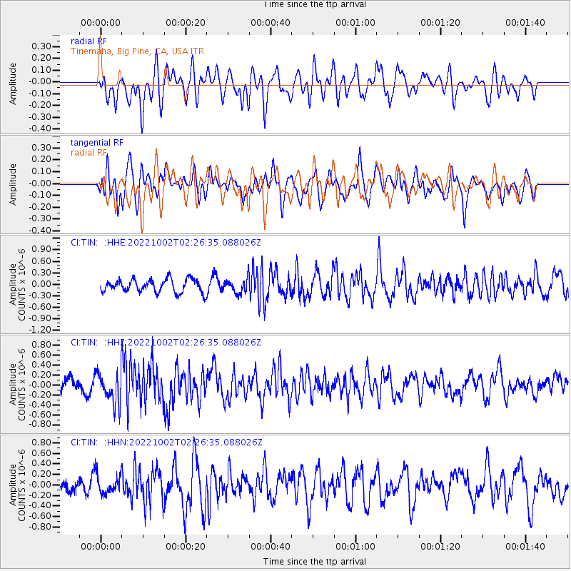
TIN Tinemaha, Big Pine, CA, USA - Earthquake Result Viewer
*The percent match for this event was below the threshold and hence no stack was calculated.
| Earthquake location: |
Mariana Islands Region |
| Earthquake latitude/longitude: |
17.0/147.1 |
| Earthquake time(UTC): |
2022/10/02 (275) 02:14:39 GMT |
| Earthquake Depth: |
20 km |
| Earthquake Magnitude: |
5.5 Mww |
| Earthquake Catalog/Contributor: |
NEIC PDE/us |
|
| Network: |
CI Caltech Regional Seismic Network |
| Station: |
TIN Tinemaha, Big Pine, CA, USA |
| Lat/Lon: |
37.05 N/118.23 W |
| Elevation: |
1197 m |
|
| Distance: |
83.6 deg |
| Az: |
53.358 deg |
| Baz: |
286.297 deg |
| Ray Param: |
$rayparam |
*The percent match for this event was below the threshold and hence was not used in the summary stack. |
|
| Radial Match: |
45.422894 % |
| Radial Bump: |
400 |
| Transverse Match: |
54.304234 % |
| Transverse Bump: |
400 |
| SOD ConfigId: |
28764291 |
| Insert Time: |
2022-10-16 02:26:35.944 +0000 |
| GWidth: |
2.5 |
| Max Bumps: |
400 |
| Tol: |
0.001 |
|
Signal To Noise
| Channel | StoN | STA | LTA |
| CI:TIN: :HHZ:20221002T02:26:35.088026Z | 2.4830105 | 3.0523483E-7 | 1.2292934E-7 |
| CI:TIN: :HHN:20221002T02:26:35.088026Z | 0.7445817 | 1.522026E-7 | 2.0441358E-7 |
| CI:TIN: :HHE:20221002T02:26:35.088026Z | 1.1313316 | 1.9239579E-7 | 1.7006136E-7 |
| Arrivals |
| Ps | |
| PpPs | |
| PsPs/PpSs | |


