You are here: Home > Network List > CN - Canadian National Seismograph Network Stations List
> Station INK INUVIK, NT > Earthquake Result Viewer
INK INUVIK, NT - Earthquake Result Viewer
*The percent match for this event was below the threshold and hence no stack was calculated.
| Earthquake location: |
Mariana Islands Region |
| Earthquake latitude/longitude: |
17.0/147.1 |
| Earthquake time(UTC): |
2022/10/02 (275) 02:14:39 GMT |
| Earthquake Depth: |
20 km |
| Earthquake Magnitude: |
5.5 Mww |
| Earthquake Catalog/Contributor: |
NEIC PDE/us |
|
| Network: |
CN Canadian National Seismograph Network |
| Station: |
INK INUVIK, NT |
| Lat/Lon: |
68.31 N/133.53 W |
| Elevation: |
44 m |
|
| Distance: |
70.4 deg |
| Az: |
22.819 deg |
| Baz: |
266.595 deg |
| Ray Param: |
$rayparam |
*The percent match for this event was below the threshold and hence was not used in the summary stack. |
|
| Radial Match: |
53.114708 % |
| Radial Bump: |
385 |
| Transverse Match: |
53.828712 % |
| Transverse Bump: |
385 |
| SOD ConfigId: |
28764291 |
| Insert Time: |
2022-10-16 02:27:22.191 +0000 |
| GWidth: |
2.5 |
| Max Bumps: |
400 |
| Tol: |
0.001 |
|
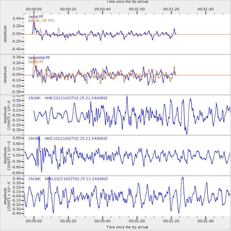
Signal To Noise
| Channel | StoN | STA | LTA |
| CN:INK: :HHZ:20221002T02:25:21.349989Z | 2.8408208 | 4.0438246E-7 | 1.4234705E-7 |
| CN:INK: :HHN:20221002T02:25:21.349989Z | 1.2569864 | 1.0554874E-7 | 8.3969674E-8 |
| CN:INK: :HHE:20221002T02:25:21.349989Z | 1.2605326 | 1.1221412E-7 | 8.9021185E-8 |
| Arrivals |
| Ps | |
| PpPs | |
| PsPs/PpSs | |


