You are here: Home > Network List > IU - Global Seismograph Network (GSN - IRIS/USGS) Stations List
> Station POHA Pohakuloa, Hawaii, USA > Earthquake Result Viewer
POHA Pohakuloa, Hawaii, USA - Earthquake Result Viewer
| Earthquake location: |
Kermadec Islands Region |
| Earthquake latitude/longitude: |
-31.8/-179.3 |
| Earthquake time(UTC): |
2018/09/10 (253) 04:19:02 GMT |
| Earthquake Depth: |
111 km |
| Earthquake Magnitude: |
6.9 mww |
| Earthquake Catalog/Contributor: |
NEIC PDE/us |
|
| Network: |
IU Global Seismograph Network (GSN - IRIS/USGS) |
| Station: |
POHA Pohakuloa, Hawaii, USA |
| Lat/Lon: |
19.76 N/155.53 W |
| Elevation: |
1990 m |
|
| Distance: |
56.2 deg |
| Az: |
27.236 deg |
| Baz: |
204.429 deg |
| Ray Param: |
0.06398919 |
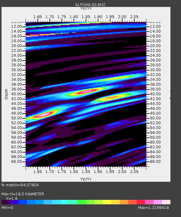
| Estimated Moho Depth: |
16.0 km |
| Estimated Crust Vp/Vs: |
1.60 |
| Assumed Crust Vp: |
5.195 km/s |
| Estimated Crust Vs: |
3.247 km/s |
| Estimated Crust Poisson's Ratio: |
0.18 |
|
| Radial Match: |
84.07604 % |
| Radial Bump: |
400 |
| Transverse Match: |
70.963715 % |
| Transverse Bump: |
400 |
| SOD ConfigId: |
2825771 |
| Insert Time: |
2018-09-24 04:36:04.976 +0000 |
| GWidth: |
2.5 |
| Max Bumps: |
400 |
| Tol: |
0.001 |
|
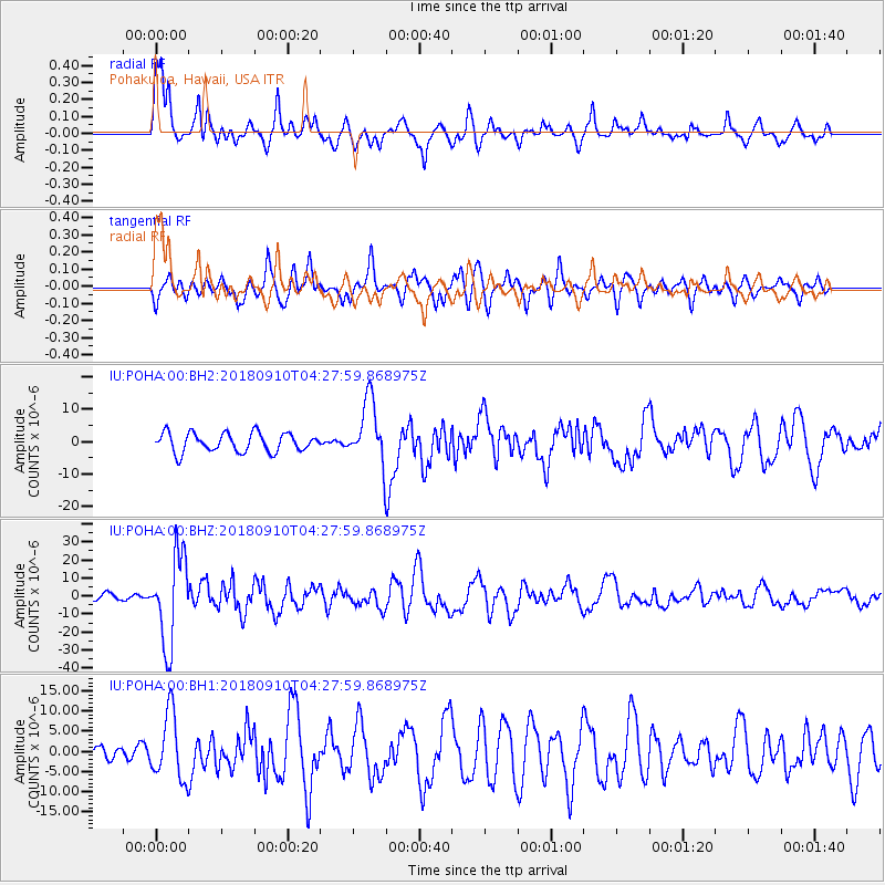
Signal To Noise
| Channel | StoN | STA | LTA |
| IU:POHA:00:BHZ:20180910T04:27:59.868975Z | 17.013802 | 2.4476514E-5 | 1.438627E-6 |
| IU:POHA:00:BH1:20180910T04:27:59.868975Z | 6.4041467 | 8.151566E-6 | 1.2728575E-6 |
| IU:POHA:00:BH2:20180910T04:27:59.868975Z | 3.3456616 | 9.721144E-6 | 2.9055968E-6 |
| Arrivals |
| Ps | 1.9 SECOND |
| PpPs | 7.7 SECOND |
| PsPs/PpSs | 9.6 SECOND |


