MM05 Gleason, Pennsylvania - Earthquake Result Viewer
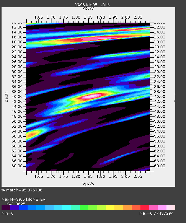
Earthquake location: Off Coast Of Northern California
Earthquake latitude/longitude: 40.6/-125.5
Earthquake time(UTC): 1995/02/19 (050) 04:03:16 GMT
Earthquake Depth: 10 km
Earthquake Magnitude: 6.1 MB, 6.8 MS, 6.7 UNKNOWN, 6.6 MD
Earthquake Catalog/Contributor: WHDF/NEIC
Network: XA Missouri to Massachusetts Transect
Station: MM05 Gleason, Pennsylvania
Lat/Lon: 41.65 N/76.92 W
Elevation: 701 m
Distance: 36.3 deg
Az: 71.924 deg
Baz: 284.877 deg
Ray Param: 0.0767811
Estimated Moho Depth: 39.5 km
Estimated Crust Vp/Vs: 1.86
Assumed Crust Vp: 6.121 km/s
Estimated Crust Vs: 3.286 km/s
Estimated Crust Poisson's Ratio: 0.30
Radial Match: 95.375786 %
Radial Bump: 342
Transverse Match: 83.741295 %
Transverse Bump: 400
SOD ConfigId: 6273
Insert Time: 2010-02-26 17:46:02.486 +0000
GWidth: 2.5
Max Bumps: 400
Tol: 0.001

Signal To Noise

ChannelStoNSTALTA
XA:MM05: :BHN:19950219T04:09:48.646014Z5.39066122.029592E-63.765015E-7
XA:MM05: :BHE:19950219T04:09:48.646014Z11.1629145.98548E-65.3619334E-7
XA:MM05: :BHZ:19950219T04:09:48.646014Z13.6669341.1414334E-58.351788E-7
Arrivals
Ps5.9 SECOND
PpPs17 SECOND
PsPs/PpSs23 SECOND