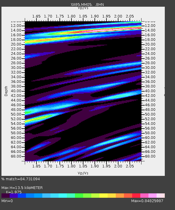
MM05 Gleason, Pennsylvania - Earthquake Result Viewer
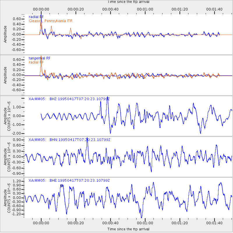
Earthquake location: Northern Mid-Atlantic Ridge
Earthquake latitude/longitude: 33.8/-38.6
Earthquake time(UTC): 1995/04/17 (107) 07:14:35 GMT
Earthquake Depth: 10 km
Earthquake Magnitude: 5.8 MB, 5.8 MS, 5.9 UNKNOWN, 6.1 MW
Earthquake Catalog/Contributor: WHDF/NEIC
Network: XA Missouri to Massachusetts Transect
Station: MM05 Gleason, Pennsylvania
Lat/Lon: 41.65 N/76.92 W
Elevation: 701 m
Distance: 31.1 deg
Az: 295.949 deg
Baz: 91.991 deg
Ray Param: 0.07915368
Estimated Moho Depth: 13.5 km
Estimated Crust Vp/Vs: 1.98
Assumed Crust Vp: 6.121 km/s
Estimated Crust Vs: 3.099 km/s
Estimated Crust Poisson's Ratio: 0.33
Radial Match: 84.731094 %
Radial Bump: 400
Transverse Match: 67.79542 %
Transverse Bump: 400
SOD ConfigId: 6273
Insert Time: 2010-02-26 17:46:04.142 +0000
GWidth: 2.5
Max Bumps: 400
Tol: 0.001

Signal To Noise

ChannelStoNSTALTA
XA:MM05: :BHN:19950417T07:20:23.10799Z1.11279961.4883845E-71.3375134E-7
XA:MM05: :BHE:19950417T07:20:23.10799Z1.96046542.7217595E-71.388323E-7
XA:MM05: :BHZ:19950417T07:20:23.10799Z2.5298235.509897E-72.1779772E-7
Arrivals
Ps2.3 SECOND
PpPs6.2 SECOND
PsPs/PpSs8.4 SECOND