You are here: Home > Network List > TX - Texas Seismological Network Stations List
> Station SN01 Snyder 1 > Earthquake Result Viewer
SN01 Snyder 1 - Earthquake Result Viewer

| Earthquake location: |
Kermadec Islands Region |
| Earthquake latitude/longitude: |
-31.8/-179.3 |
| Earthquake time(UTC): |
2018/09/10 (253) 04:19:02 GMT |
| Earthquake Depth: |
111 km |
| Earthquake Magnitude: |
6.9 mww |
| Earthquake Catalog/Contributor: |
NEIC PDE/us |
|
| Network: |
TX Texas Seismological Network |
| Station: |
SN01 Snyder 1 |
| Lat/Lon: |
32.86 N/100.89 W |
| Elevation: |
717 m |
|
| Distance: |
98.0 deg |
| Az: |
56.386 deg |
| Baz: |
237.366 deg |
| Ray Param: |
0.039930634 |
| Estimated Moho Depth: |
45.5 km |
| Estimated Crust Vp/Vs: |
1.73 |
| Assumed Crust Vp: |
6.426 km/s |
| Estimated Crust Vs: |
3.725 km/s |
| Estimated Crust Poisson's Ratio: |
0.25 |
|
| Radial Match: |
84.33019 % |
| Radial Bump: |
322 |
| Transverse Match: |
81.34718 % |
| Transverse Bump: |
358 |
| SOD ConfigId: |
2825771 |
| Insert Time: |
2018-09-24 04:37:04.477 +0000 |
| GWidth: |
2.5 |
| Max Bumps: |
400 |
| Tol: |
0.001 |
|
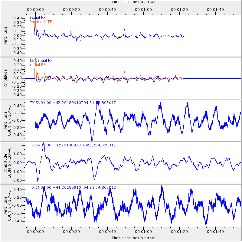
Signal To Noise
| Channel | StoN | STA | LTA |
| TX:SN01:00:HHZ:20180910T04:31:54.80501Z | 9.883895 | 1.2485223E-6 | 1.2631885E-7 |
| TX:SN01:00:HH1:20180910T04:31:54.80501Z | 1.9267988 | 2.1859329E-7 | 1.1344894E-7 |
| TX:SN01:00:HH2:20180910T04:31:54.80501Z | 2.9225075 | 3.3189195E-7 | 1.13564106E-7 |
| Arrivals |
| Ps | 5.2 SECOND |
| PpPs | 19 SECOND |
| PsPs/PpSs | 24 SECOND |


