You are here: Home > Network List > XA95 - Missouri to Massachusetts Transect Stations List
> Station MM05 Gleason, Pennsylvania > Earthquake Result Viewer
MM05 Gleason, Pennsylvania - Earthquake Result Viewer
| Earthquake location: |
Gulf Of California |
| Earthquake latitude/longitude: |
26.2/-110.3 |
| Earthquake time(UTC): |
1995/08/28 (240) 10:46:12 GMT |
| Earthquake Depth: |
10 km |
| Earthquake Magnitude: |
5.6 MB, 6.5 MS |
| Earthquake Catalog/Contributor: |
WHDF/NEIC |
|
| Network: |
XA Missouri to Massachusetts Transect |
| Station: |
MM05 Gleason, Pennsylvania |
| Lat/Lon: |
41.65 N/76.92 W |
| Elevation: |
701 m |
|
| Distance: |
31.5 deg |
| Az: |
52.145 deg |
| Baz: |
251.25 deg |
| Ray Param: |
0.079040736 |
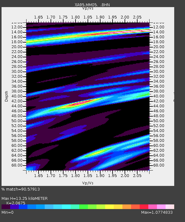
| Estimated Moho Depth: |
13.25 km |
| Estimated Crust Vp/Vs: |
2.07 |
| Assumed Crust Vp: |
6.121 km/s |
| Estimated Crust Vs: |
2.96 km/s |
| Estimated Crust Poisson's Ratio: |
0.35 |
|
| Radial Match: |
90.57913 % |
| Radial Bump: |
400 |
| Transverse Match: |
58.012184 % |
| Transverse Bump: |
400 |
| SOD ConfigId: |
6273 |
| Insert Time: |
2010-02-26 17:46:07.308 +0000 |
| GWidth: |
2.5 |
| Max Bumps: |
400 |
| Tol: |
0.001 |
|
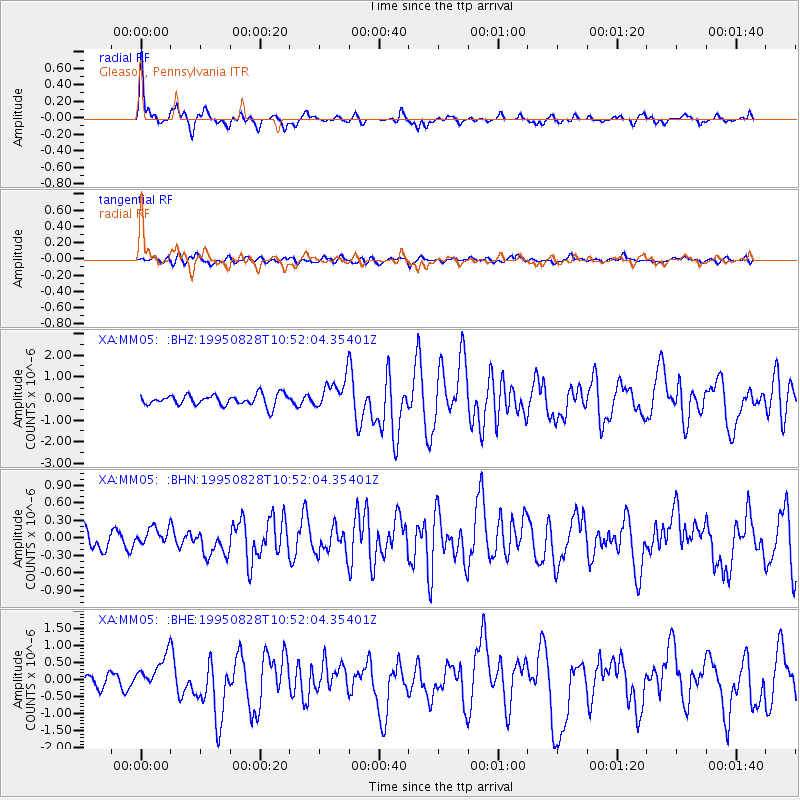
Signal To Noise
| Channel | StoN | STA | LTA |
| XA:MM05: :BHN:19950828T10:52:04.35401Z | 0.7843523 | 1.5531553E-7 | 1.9801757E-7 |
| XA:MM05: :BHE:19950828T10:52:04.35401Z | 3.1760938 | 5.156962E-7 | 1.6236805E-7 |
| XA:MM05: :BHZ:19950828T10:52:04.35401Z | 2.8208413 | 7.2920807E-7 | 2.585073E-7 |
| Arrivals |
| Ps | 2.5 SECOND |
| PpPs | 6.2 SECOND |
| PsPs/PpSs | 8.7 SECOND |


