You are here: Home > Network List > TX - Texas Seismological Network Stations List
> Station PB11 Snyder 1 > Earthquake Result Viewer
PB11 Snyder 1 - Earthquake Result Viewer
| Earthquake location: |
Kermadec Islands Region |
| Earthquake latitude/longitude: |
-31.8/-179.3 |
| Earthquake time(UTC): |
2018/09/10 (253) 04:19:02 GMT |
| Earthquake Depth: |
111 km |
| Earthquake Magnitude: |
6.9 mww |
| Earthquake Catalog/Contributor: |
NEIC PDE/us |
|
| Network: |
TX Texas Seismological Network |
| Station: |
PB11 Snyder 1 |
| Lat/Lon: |
31.94 N/104.03 W |
| Elevation: |
915 m |
|
| Distance: |
95.3 deg |
| Az: |
55.686 deg |
| Baz: |
235.771 deg |
| Ray Param: |
0.04073299 |
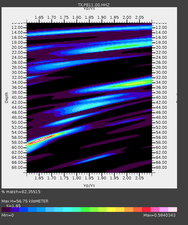
| Estimated Moho Depth: |
56.75 km |
| Estimated Crust Vp/Vs: |
1.65 |
| Assumed Crust Vp: |
6.361 km/s |
| Estimated Crust Vs: |
3.855 km/s |
| Estimated Crust Poisson's Ratio: |
0.21 |
|
| Radial Match: |
82.35515 % |
| Radial Bump: |
400 |
| Transverse Match: |
62.257526 % |
| Transverse Bump: |
400 |
| SOD ConfigId: |
2825771 |
| Insert Time: |
2018-09-24 04:37:25.015 +0000 |
| GWidth: |
2.5 |
| Max Bumps: |
400 |
| Tol: |
0.001 |
|

Signal To Noise
| Channel | StoN | STA | LTA |
| TX:PB11:00:HHZ:20180910T04:31:42.589983Z | 9.003445 | 1.6139415E-6 | 1.7925822E-7 |
| TX:PB11:00:HH1:20180910T04:31:42.589983Z | 2.8887591 | 2.2393772E-7 | 7.752038E-8 |
| TX:PB11:00:HH2:20180910T04:31:42.589983Z | 1.4071782 | 1.8113171E-7 | 1.287198E-7 |
| Arrivals |
| Ps | 5.9 SECOND |
| PpPs | 23 SECOND |
| PsPs/PpSs | 29 SECOND |


