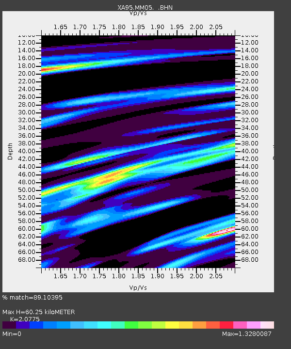
MM05 Gleason, Pennsylvania - Earthquake Result Viewer
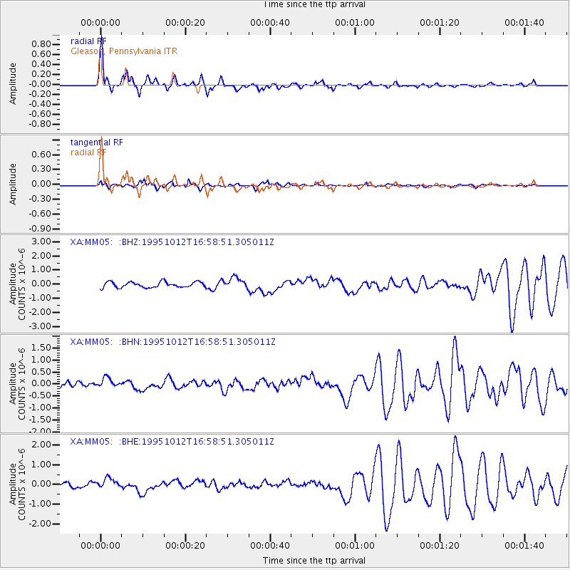
Earthquake location: Near Coast Of Jalisco, Mexico
Earthquake latitude/longitude: 18.8/-104.0
Earthquake time(UTC): 1995/10/12 (285) 16:52:54 GMT
Earthquake Depth: 25 km
Earthquake Magnitude: 5.5 MB, 5.5 MS, 5.2 UNKNOWN, 6.0 MW
Earthquake Catalog/Contributor: WHDF/NEIC
Network: XA Missouri to Massachusetts Transect
Station: MM05 Gleason, Pennsylvania
Lat/Lon: 41.65 N/76.92 W
Elevation: 701 m
Distance: 32.4 deg
Az: 39.565 deg
Baz: 233.612 deg
Ray Param: 0.078638144
Estimated Moho Depth: 60.25 km
Estimated Crust Vp/Vs: 2.08
Assumed Crust Vp: 6.121 km/s
Estimated Crust Vs: 2.946 km/s
Estimated Crust Poisson's Ratio: 0.35
Radial Match: 89.10395 %
Radial Bump: 400
Transverse Match: 82.61149 %
Transverse Bump: 400
SOD ConfigId: 6273
Insert Time: 2010-02-26 17:46:11.990 +0000
GWidth: 2.5
Max Bumps: 400
Tol: 0.001

Signal To Noise

ChannelStoNSTALTA
XA:MM05: :BHN:19951012T16:58:51.305011Z2.20697622.3767453E-71.0769239E-7
XA:MM05: :BHE:19951012T16:58:51.305011Z1.74143972.6842548E-71.5413997E-7
XA:MM05: :BHZ:19951012T16:58:51.305011Z2.04515463.9846324E-71.9483284E-7
Arrivals
Ps11 SECOND
PpPs29 SECOND
PsPs/PpSs40 SECOND