You are here: Home > Network List > UU - University of Utah Regional Network Stations List
> Station CVRU Castle Valley Ranch, Emery, UT, USA old TA-Q16A > Earthquake Result Viewer
CVRU Castle Valley Ranch, Emery, UT, USA old TA-Q16A - Earthquake Result Viewer
| Earthquake location: |
Kermadec Islands Region |
| Earthquake latitude/longitude: |
-31.8/-179.3 |
| Earthquake time(UTC): |
2018/09/10 (253) 04:19:02 GMT |
| Earthquake Depth: |
111 km |
| Earthquake Magnitude: |
6.9 mww |
| Earthquake Catalog/Contributor: |
NEIC PDE/us |
|
| Network: |
UU University of Utah Regional Network |
| Station: |
CVRU Castle Valley Ranch, Emery, UT, USA old TA-Q16A |
| Lat/Lon: |
38.92 N/111.17 W |
| Elevation: |
1912 m |
|
| Distance: |
94.7 deg |
| Az: |
46.597 deg |
| Baz: |
232.434 deg |
| Ray Param: |
0.040904306 |
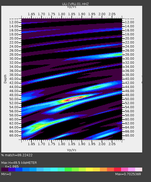
| Estimated Moho Depth: |
49.5 km |
| Estimated Crust Vp/Vs: |
1.87 |
| Assumed Crust Vp: |
6.207 km/s |
| Estimated Crust Vs: |
3.328 km/s |
| Estimated Crust Poisson's Ratio: |
0.30 |
|
| Radial Match: |
89.22422 % |
| Radial Bump: |
396 |
| Transverse Match: |
81.85123 % |
| Transverse Bump: |
400 |
| SOD ConfigId: |
2825771 |
| Insert Time: |
2018-09-24 04:38:08.193 +0000 |
| GWidth: |
2.5 |
| Max Bumps: |
400 |
| Tol: |
0.001 |
|
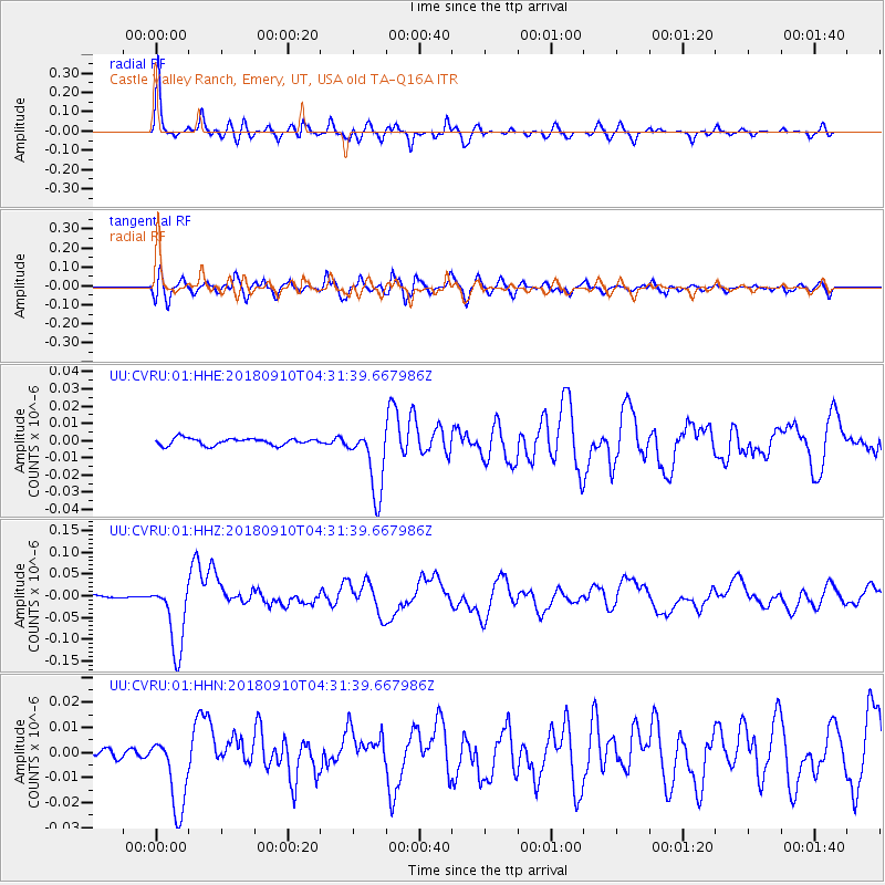
Signal To Noise
| Channel | StoN | STA | LTA |
| UU:CVRU:01:HHZ:20180910T04:31:39.667986Z | 23.83616 | 8.047758E-8 | 3.376281E-9 |
| UU:CVRU:01:HHN:20180910T04:31:39.667986Z | 7.726134 | 1.506918E-8 | 1.9504165E-9 |
| UU:CVRU:01:HHE:20180910T04:31:39.667986Z | 9.9126835 | 1.9703036E-8 | 1.9876591E-9 |
| Arrivals |
| Ps | 7.0 SECOND |
| PpPs | 22 SECOND |
| PsPs/PpSs | 29 SECOND |


