You are here: Home > Network List > CC - Cascade Chain Volcano Monitoring Stations List
> Station TIMB Timberline, OR > Earthquake Result Viewer
TIMB Timberline, OR - Earthquake Result Viewer
| Earthquake location: |
Peru-Ecuador Border Region |
| Earthquake latitude/longitude: |
-4.9/-80.6 |
| Earthquake time(UTC): |
2022/10/05 (278) 08:26:21 GMT |
| Earthquake Depth: |
48 km |
| Earthquake Magnitude: |
5.8 Mww |
| Earthquake Catalog/Contributor: |
NEIC PDE/us |
|
| Network: |
CC Cascade Chain Volcano Monitoring |
| Station: |
TIMB Timberline, OR |
| Lat/Lon: |
45.34 N/121.71 W |
| Elevation: |
1869 m |
|
| Distance: |
62.0 deg |
| Az: |
328.299 deg |
| Baz: |
132.071 deg |
| Ray Param: |
0.060389794 |
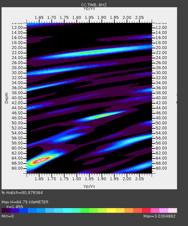
| Estimated Moho Depth: |
64.75 km |
| Estimated Crust Vp/Vs: |
1.65 |
| Assumed Crust Vp: |
6.597 km/s |
| Estimated Crust Vs: |
3.986 km/s |
| Estimated Crust Poisson's Ratio: |
0.21 |
|
| Radial Match: |
80.879364 % |
| Radial Bump: |
400 |
| Transverse Match: |
66.90616 % |
| Transverse Bump: |
400 |
| SOD ConfigId: |
28764291 |
| Insert Time: |
2022-10-19 08:36:45.591 +0000 |
| GWidth: |
2.5 |
| Max Bumps: |
400 |
| Tol: |
0.001 |
|

Signal To Noise
| Channel | StoN | STA | LTA |
| CC:TIMB: :BHZ:20221005T08:36:06.139994Z | 3.6323292 | 4.289912E-7 | 1.18103614E-7 |
| CC:TIMB: :BHN:20221005T08:36:06.139994Z | 2.6171708 | 3.438836E-7 | 1.3139518E-7 |
| CC:TIMB: :BHE:20221005T08:36:06.139994Z | 2.0472047 | 4.0733968E-7 | 1.9897361E-7 |
| Arrivals |
| Ps | 6.8 SECOND |
| PpPs | 25 SECOND |
| PsPs/PpSs | 32 SECOND |


