You are here: Home > Network List > UU - University of Utah Regional Network Stations List
> Station LCMT Little Creek Mountain, UT, USA > Earthquake Result Viewer
LCMT Little Creek Mountain, UT, USA - Earthquake Result Viewer
| Earthquake location: |
Kermadec Islands Region |
| Earthquake latitude/longitude: |
-31.8/-179.3 |
| Earthquake time(UTC): |
2018/09/10 (253) 04:19:02 GMT |
| Earthquake Depth: |
111 km |
| Earthquake Magnitude: |
6.9 mww |
| Earthquake Catalog/Contributor: |
NEIC PDE/us |
|
| Network: |
UU University of Utah Regional Network |
| Station: |
LCMT Little Creek Mountain, UT, USA |
| Lat/Lon: |
37.01 N/113.24 W |
| Elevation: |
1411 m |
|
| Distance: |
92.2 deg |
| Az: |
47.08 deg |
| Baz: |
231.135 deg |
| Ray Param: |
0.041442383 |
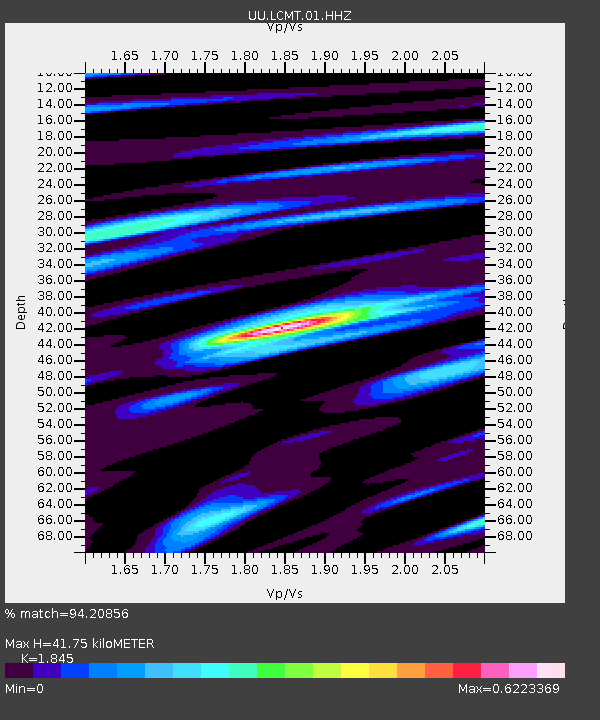
| Estimated Moho Depth: |
41.75 km |
| Estimated Crust Vp/Vs: |
1.85 |
| Assumed Crust Vp: |
6.194 km/s |
| Estimated Crust Vs: |
3.357 km/s |
| Estimated Crust Poisson's Ratio: |
0.29 |
|
| Radial Match: |
94.20856 % |
| Radial Bump: |
362 |
| Transverse Match: |
78.01228 % |
| Transverse Bump: |
400 |
| SOD ConfigId: |
2825771 |
| Insert Time: |
2018-09-24 04:38:26.179 +0000 |
| GWidth: |
2.5 |
| Max Bumps: |
400 |
| Tol: |
0.001 |
|
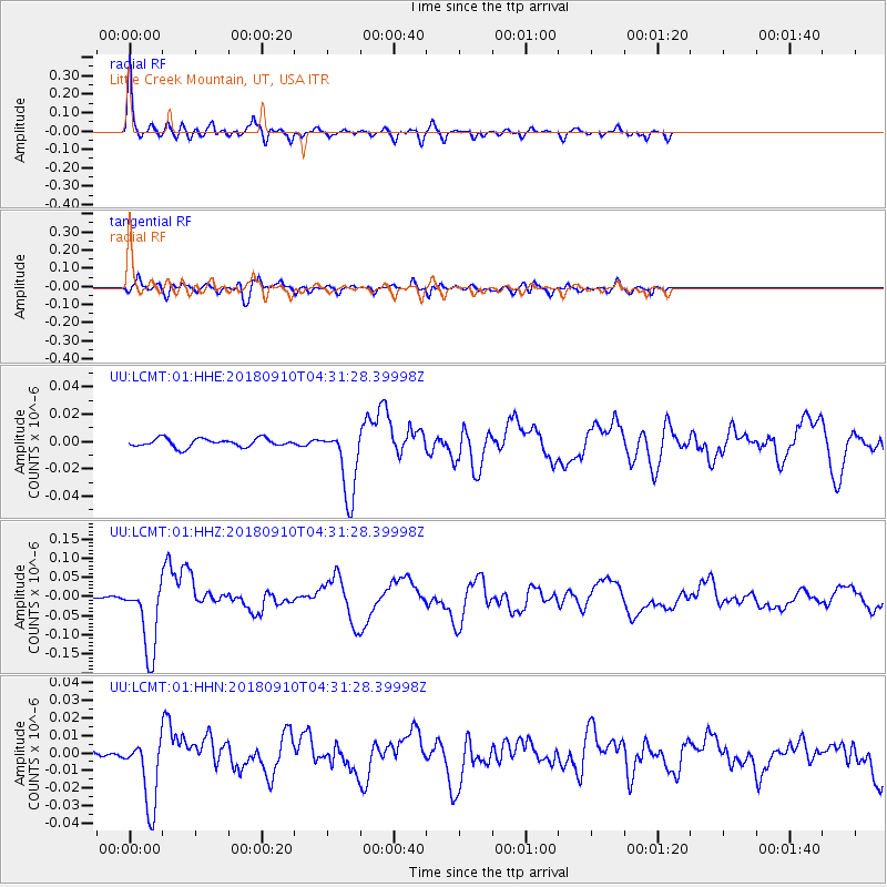
Signal To Noise
| Channel | StoN | STA | LTA |
| UU:LCMT:01:HHZ:20180910T04:31:28.39998Z | 24.976957 | 9.536601E-8 | 3.8181596E-9 |
| UU:LCMT:01:HHN:20180910T04:31:28.39998Z | 9.345448 | 2.042997E-8 | 2.186088E-9 |
| UU:LCMT:01:HHE:20180910T04:31:28.39998Z | 8.523784 | 2.5942382E-8 | 3.043529E-9 |
| Arrivals |
| Ps | 5.8 SECOND |
| PpPs | 19 SECOND |
| PsPs/PpSs | 25 SECOND |


