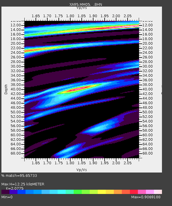
MM05 Gleason, Pennsylvania - Earthquake Result Viewer
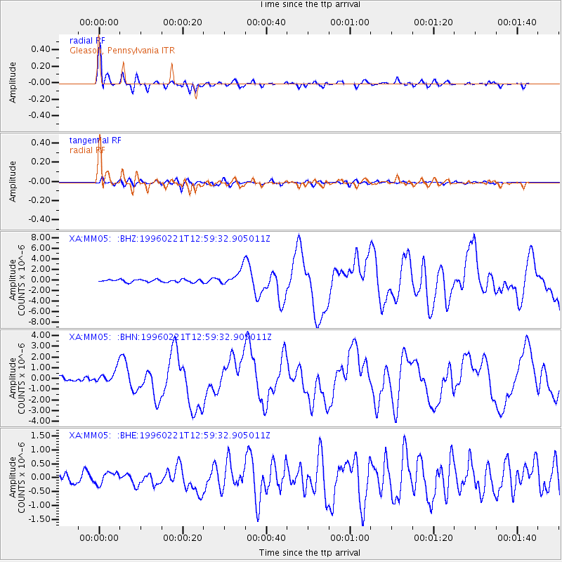
Earthquake location: Off Coast Of Northern Peru
Earthquake latitude/longitude: -9.6/-79.6
Earthquake time(UTC): 1996/02/21 (052) 12:51:04 GMT
Earthquake Depth: 33 km
Earthquake Magnitude: 5.8 MB, 6.6 MS, 7.5 UNKNOWN, 7.3 MW
Earthquake Catalog/Contributor: WHDF/NEIC
Network: XA Missouri to Massachusetts Transect
Station: MM05 Gleason, Pennsylvania
Lat/Lon: 41.65 N/76.92 W
Elevation: 701 m
Distance: 51.1 deg
Az: 2.549 deg
Baz: 183.355 deg
Ray Param: 0.06757988
Estimated Moho Depth: 12.25 km
Estimated Crust Vp/Vs: 2.08
Assumed Crust Vp: 6.121 km/s
Estimated Crust Vs: 2.946 km/s
Estimated Crust Poisson's Ratio: 0.35
Radial Match: 95.65733 %
Radial Bump: 382
Transverse Match: 73.57637 %
Transverse Bump: 400
SOD ConfigId: 6273
Insert Time: 2010-02-26 17:46:13.999 +0000
GWidth: 2.5
Max Bumps: 400
Tol: 0.001

Signal To Noise

ChannelStoNSTALTA
XA:MM05: :BHN:19960221T12:59:32.905011Z3.0166787.2028087E-72.3876623E-7
XA:MM05: :BHE:19960221T12:59:32.905011Z1.16584232.1608457E-71.8534632E-7
XA:MM05: :BHZ:19960221T12:59:32.905011Z6.6721571.6344986E-62.4497305E-7
Arrivals
Ps2.3 SECOND
PpPs5.9 SECOND
PsPs/PpSs8.1 SECOND